


Gear
What should I expect on AZT in a Day?
Plan for the worst, expect the best.
Please get familiar with your leg before October 5th, so that you know what to expect from the day before the day gets here. The AZT is beautifully diverse, and as such, it’s impossibly hard for the Arizona Trail Association to prepare everyone for their specific area of the trail. We’ve provided as many resources as we can to participants, but this event is designed for participants to self-prep, self-support, and even self-organize.
What should I carry with me?
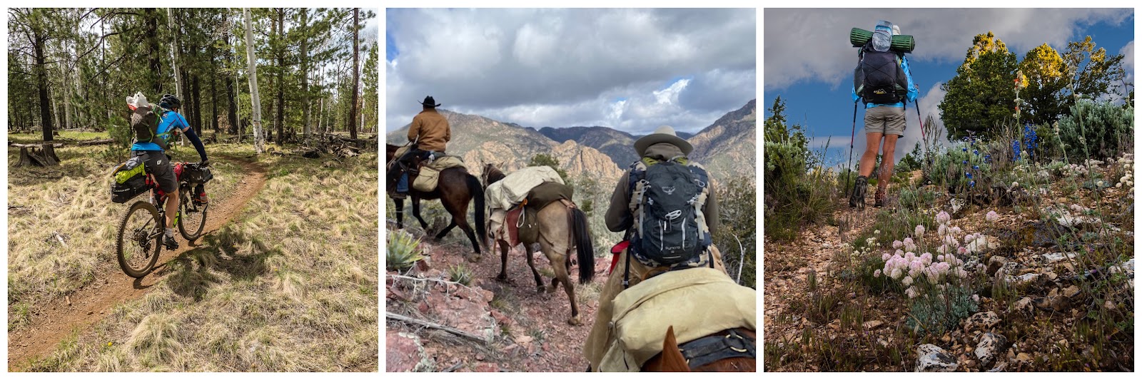
Day hiking is inherently more dangerous than overnight backpacking.
Think about it. On AZT in a Day, you may be visiting areas that are just as remote as people who are backpacking on the AZT. The main difference is that backpackers are carrying a lot more resources on their backs that they can use if something goes wrong. If a backpacker gets lost or injured they have a tent, sleeping bag, extra food, and a lot of other tools with them that can help them handle their situation.
Even as a day hiker you should consider carrying additional resources with you for your safety. Plan on bringing items that some day-hikers might not normally consider bringing, such as:
Extra water, headlamp, rain jacket, larger first aid kit, compass, GPS, water treatment/filter, spot device, extra food, whistle, winter hat, warm socks, medications, pocket knife, lighter and extra batteries for headlamp and GPS.
The AZT was intentionally routed through wild, remote parts of the state to provide a primitive experience to the backcountry traveler. In some places, help will be far away and preparation for hazards is essential. Anyone considering a hike along the AZT should carefully evaluate their ability to cope with potential dangers. Remember, self-rescue is always the primary means of dealing with an emergency and is often the fastest. Search & Rescue missions to assist lost or injured trail users can take a very long time, depending on how far from the nearest road the patient may be.
Cellular telephone coverage is intermittent and unreliable along much of the AZT. Carrying a satellite communication device is a better option, but they are no substitute for good trail sense and on-the-ground experience. It’s always best to leave a detailed itinerary with a reliable friend or family member and check in with them regularly to acknowledge you are safe and on track. Knowing the point last seen is a vital piece of information for rescue personnel.
Weather
What will the weather be like?
October in southern Arizona is typically dry and sunny. Higher elevations are more likely to be cooler and/or receive rainfall. In lower elevations (near Phoenix) temperatures are between 89 degrees F and 64 degrees F.
In October 2018, the North Rim of the Grand Canyon experienced lightning and snow on AZT in a Day, while the southern legs had near-perfect weather. So, it’s best to check the weather on the day of the event and plan accordingly.
Is there a rain date?
No. AZT in a Day is on rain or shine. Please be prepared adequately. We will be in touch with information on trail closures, road closures, weather advisories, and reroutes as October approaches. Please always use your best judgment when heading outdoors, and do not sacrifice your safety.
Group Size
Is there a limit on group size?
In some cases there is a legal limit on group size. Some wilderness areas and national forests along the AZT have regulations that require 15 or fewer people in a group.
We also recommend groups <10 people, as smaller groups offer added benefits for both the people in the group, and others enjoying the same trail. Smaller groups…
- Reduce noise levels
- Make it easier for other groups to pass you
- Allow your group to move faster and stay together more easily
- Provide more opportunities for everyone in the group to view wildlife
- Come equipped with more group leaders, which means more people who should know how the day is supposed to go.
Groups 10+ should stagger start:
Just say, you have a group of 20 people, and you really want to do the same leg. We recommend splitting your group into two groups of ten (who each have their own map, water, food, first aid kit, cell phone, etc.) and then start at least 30 minutes apart. If you meet up down the trail, stagger again into two distinct groups.
Is there a limit to how many people can sign up for a leg?
Yes. Registration is limited to 25 people per leg. If you see a leg is full, please look at other leg that need more coverage. This will help us meet our goal of covering every mile of the trail on October 5th, but it will also provide a more scenic and relaxing experience for those of us who are out there.
Participating
Can I complete my leg before or after October 5th, 2024?
We encourage you to get out on the Arizona Trail on any day of the year. However, to participate in AZT in a Day, you’ll need to complete your leg on October 5th, 2024. Completing your leg one day before or after will not add to our total mileage for the day, or to the full completion we’re attempting.
Do I need to complete my leg in a certain direction?
You can travel in either direction unless your leg is only accessible from one side.
Can I complete a partial leg?
You are welcome to hike as much or as little as you would like for AZT in a Day. We’re happy to have you either way. We encourage you to pick a leg that is at a length you can complete rather than doing a partial leg somewhere else. This allows us to ensure that we have full coverage of the entire AZT, and not partial coverage everywhere.
If you would like to sign up for a partial leg, please email shane@wanderlustrunningunlimited.com, so that we can sort it out together. If you know anyone that would like to complete the entire leg, or the other half of the leg you’re planning to complete a smaller portion of, please send them our way!
Can I complete more than one leg?
If you are interested in signing up for more than one leg, please email shane@wanderlustrunningunlimited.com.
We recommend signing up for less than 5 legs so that participants don’t overextend their day. We would rather have multiple folks completing portions of the trail than have only one person covering 100 miles.
Can I bring my dog?
Please see our website for more information about dogs on the AZT. Where dogs are allowed, they must be on a leash no greater than 6 feet in length.
Dogs are NOT allowed on trails within the following areas:
- Coronado National Memorial (Passage 1 – Leg 1)
- Saguaro National Park (Passage 9 – Legs 16 and 17)
- Pusch Ridge Wilderness (Passages 11 and 12 – Legs 20 and 21)
- Grand Canyon National Park (Passages 37, 38 and 39 – Legs 77, 78, 79, 80, 81 and 82)
What is “Leave No Trace,” or LNT?
Our wild and scenic places only remain wild and scenic if we attempt to limit our impact. Leave the Arizona Trail better than you found it, so that it may continue to bring the same joy, wonder and beauty to future generations.
Here are the 7 Leave No Trace Principles:
- Plan Ahead and Prepare
- Travel and Camp on Durable Surfaces
- Dispose of Waste Properly
- Leave What You Find
- Minimize Campfire Impacts
- Respect Wildlife
- Be Considerate of Other Visitors.
Go here to learn more: https://lnt.org
If you choose, you can pack a small grocery bag with you on AZT in a Day to help pick up small pieces of litter. Please use gloves. Do not pick up any sanitary items, like toilet paper, feminine products, or wet wipes.
Why are certain legs closed to mountain bikes and equestrians?
The AZT goes through 8 wilderness areas, 2 National Parks, and 1 National Memorial. Travel in these areas is closed to mountain bike traffic. Please respect this closure and use the parts of the trail open to bikes.
Travel in the Coronado National Memorial is closed to equestrians. Please respect this closure and use the parts of the trail open to horse and pack animal traffic.
Are there wheelchair-accessible legs?
Very few areas on the AZT offer accessible hiking opportunities. The Arizona National Scenic Trail is a remote and primitive wilderness route. Its tread is a narrow, singletrack trail maintained to 24” wide.
However, the ATA welcomes all non-motorized user groups to enjoy this trail and we are developing a guide to help people with disabilities experience the AZT. We’ve identified four places where the trail, or access trails, feature wider tread, gentler slopes, and stable surfaces. Parking options have been considered as well as accessible amenities. Please contact Matt Nelson matthew@aztrail.org for more information.
Why are the Grand Canyon legs full?
The inner gorge of the Grand Canyon is well covered, and the Park Service has requested that we remove these legs from the drop-down menu at sign-up to discourage an influx of people on AZT in a Day. We’re asking folks to check out other legs that still need participants.
There are dozens that are still up for grabs since it’s early in the registration process. This year each section is capped at 25 participants to encourage folks to spread out. We need folks like you who are willing to take on something as difficult as the Grand Canyon in other critical areas on Oct 5th.
Volunteering
- Raising money for your campaign and promoting within your team
- Hosts activities to add value to AZT in a Day such as cookouts, shuttles and water caching
- Do an assessment while you’re out there and long your findings on our Trail Conditions Form.
Log your volunteer time through your personal Engagement Dashboard (if you don’t have one yet, you can request one here). If you have any questions about volunteering for AZT in a Day or other ATA events, email volunteer@aztrail.org.
T-Shirts
Where can I get an AZT in a Day shirt?
You can order your custom AZT in a Day 2024 shirt here!
Legs
Where can I find more info about the legs?
- Interactive Map: This is a free resource that displays all of the legs for AZT in a Day. You can learn a lot by just clicking around. Find a leg that’s close to you!
- Day Hiker’s Guide: The AZT in a Day legs are based on this guide. A free digital copy is available to Arizona Trail Association members.
- The Guidebook: A detailed, and beautiful guide to the entire AZT.
- Guthook’s App: A smartphone app that provides users with updated water reports, and GPS tracks of the AZT that work even when in airplane mode.
- ATA Website: Here you can find free maps and GPS tracks of the trail, along with information on closures and other alerts.
Interactive Map
How do I use the interactive map?
There are two ways to navigate this resource. You can either 1) use the list on the left side of the screen, or you can 2) use the map on the right side of the screen. Both navigation methods display the same information. Click around and explore, find the leg nearest to your house, or go somewhere new.
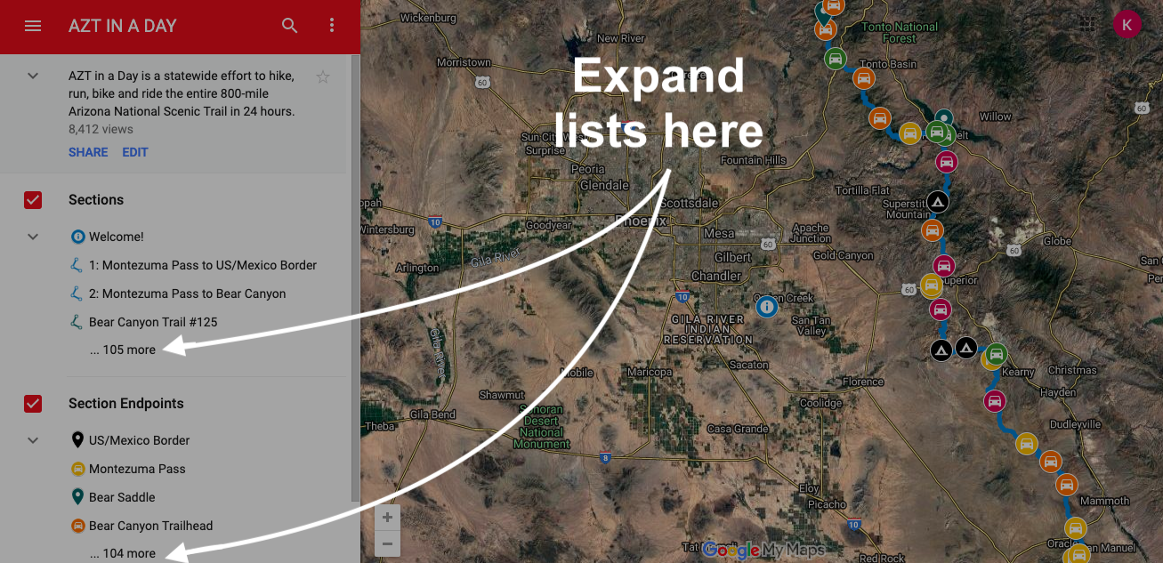
We recommend using full-screen mode, as shown below:
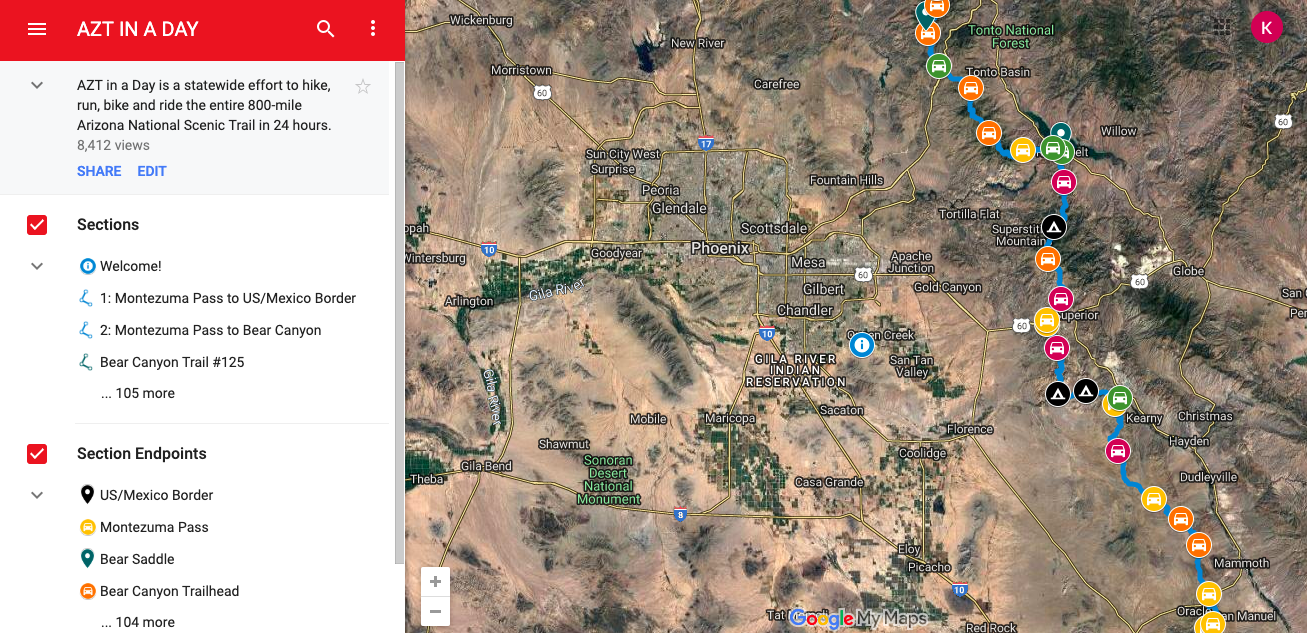
The full list of legs (formerly called “sections”) and their start/endpoints will appear on the left-hand side of the screen. This list can be expanded to show all available legs and all endpoints by clicking on the “…103 more” under “Legs” and the “…102 more” under “Leg Endpoints.”
You can click on any of these legs or leg endpoints to learn more about them. For example, clicking on leg “78: South Kaibab to Bright Angel CG” brings up the image below. The leg will be highlighted on the map to the right, and information about the leg will appear on the left.
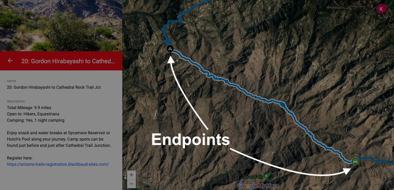
For all legs, the endpoints are a part of the leg name. For example, leg 20 goes from “Gordon Hirabayashi” to the “Cathedral Rock Trail Jtc.” From here, the easiest way to learn more about these places is to utilize the map feature on the right. Click on either end point to learn more.
Clicking on the green car icon (lower right in the image above) brings up more information about the Gordon Hirabayashi Trailhead endpoint.
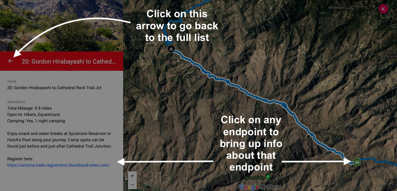
To return to the large list of all legs and leg endpoints, click the back arrow in the upper left of the sidebar.
Other notes on the map:
The map on the right of your screen also features all of the legs and their endpoints. The legs are represented by blue lines. You’ll have to zoom in to see them. The leg endpoints appear as cars and tents. Click on any leg (blue line) or icon (leg endpoint) to learn more about it. When you do, the information will slide in from the left-hand side of your screen.
To change the zoom, use the plus and minus buttons in the center bottom of the screen (“+” to zoom in and the “-“ to zoom out). Scrolling up with a mouse will also zoom in and scrolling down will zoom out. You can pinch or expand using a trackpad on a laptop. You can also use your mouse to hold and drag the map around to center different areas.
To return to the large list of all legs and leg endpoints, click the back arrow next to the title of the leg endpoint that you clicked.
What do the different colors mean on the interactive map?
The colors are road quality ratings. This lets you know what type of vehicle you will need to get to that point on the map. If you see a tent, there is no road access, and camping may be required.

Leg Spreadsheet
The spreadsheet on our registration page is another way to view the legs. The sheet lists the total distance (including access trails), user groups allowed (hikers, bikers, and/or equestrians), and the likelihood of needing to camp in each leg. Please use the interactive map to get directions to trailheads, check the suggested vehicles needed, and learn even more.
Can’t find what you’re looking for?
Email shane@wanderlustrunningunlimited.com
Registering
Do I need to create a Race Roster account to register?
If you don’t already have one, then yes. We are utilizing Race Roster to manage registration and donations for AZT in a Day. Since Race Roster is a fundraising platform, you receive a fundraising page automatically when you register.
Fundraising is optional. However, please hang on to your page, even if you don’t intend to fundraise; deleting it will remove your registration from the event.
Register here: https://raceroster.com/events/2024/83424/azt-in-a-day-2024
How can I find out what leg(s) I signed up for?
The day you sign up, you should receive a confirmation email in your inbox titled, “AZT in a Day 2024 — Event Confirmation.” Near the bottom of the email, under “Manage Registration” click the button “Visit Dashboard,” and log into Race Roster.
If you can’t find this email, please reach out to Shane: shane@wanderlustrunningunlimited.com

Once you login, and are viewing your dashboard, you will see the leg you chose under “Products” near the middle of the page.

How can I change, add or remove a leg from my registration?
Please email to let us know you’d like to switch things up. This way we can keep track of who is where and make sure we’re ready to cover the AZT in October. Please reach out to Shane: shane@wanderlustrunningunlimited.com
How can I add people to my registration?
Please email shane@wanderlustrunningunlimited.com to let us know you’d like to switch things up.
I can no longer complete my leg, is that okay?
Of course, it’s okay. We realize that life happens, things come up, and sometimes interest fades. But if you decide that you cannot complete your leg, please email us and let us know as soon as you can at shane@wanderlustrunningunlimited.com.
We really want to cover the whole Arizona Trail in a single day, and we can’t do that if we don’t have legs covered. Even if you see someone else is signed up for your slot, letting us know helps us keep an accurate headcount.
Donating
Thank you for your generosity! You can donate to AZT in a day in three places on the event landing page. If you’re looking to donate to a specific participant to help them toward their fundraising goal, use the donate to participant link in the upper right and follow the on screen prompts.

Fundraising
Do you have any tips for reaching my fundraising goal?
We sure do! Check out our Fundraising Toolkit for tips on how to tell your story. This page includes a Fundraising Timeline to help keep you on track towards your goal.
Remember!
- Just for registering, you (and everyone else in your group) will receive a limited edition AZT in a Day 2024 sticker. AND each person who donates $25 or more to your page will also get a sticker after AZT in a Day, Oct 5.
- For every $50 raised by you, you’ll receive an automatic entry into our AZT in a Day raffle! To learn more about the raffle, please contact brittany@aztrail.org
Race Roster Page
How can I make edits to my Race Roster Page?
If you would like to make tweaks to your page:
- Log into your Race Roster Account and go to your dashboard
- Click ‘Edit Page’ on the far right side

- Here you can make changes to your target, story and even add a photo of yourself.
How can I share my Race Roster Page?
- Go to your page and click “Share page” in the lower right. Share your page with your friends and family to help you reach your fundraising goals!

How do I cancel my Race Roster Page?
PLEASE NOTE: Disabling or deleting your Race Roster page will also remove your registration for the event.
Before deleting/canceling your page, please contact Shane: shane@wanderlustrunningunlimited.com
Networking
How do I get in touch with others in my leg?
We will have a Facebook event up and running soon. This is a great place to meet other folks who are participating in the event and stay updated. You can also reach out to the event coordinator, Shane Asbury: shane@wanderlustrunningunlimited.com, and he can put you in touch with others in your section.
Other Questions?
Please contact Shane: shane@wanderlustrunningunlimited.com. We’ll sort it out. Thank you for joining us on the trail.
