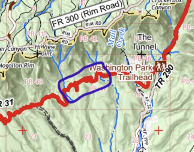
From the intersection of AZ 87 and AZ 260 north of Pine, drive east 2.6 miles on AZ 87 then turn right (south) toward FR 300. Go 0.1 miles and turn left onto FR 300. Avoid the frequent side roads and drive 12 miles on FR 300 to a turnoff on the left (north) at a historical marker for the Battle of Big Dry Wash. This is where the AZT crosses FR 300. Turn left and follow a power line 0.3 mile to General Springs Cabin. The road curves right to a small parking area and the trailhead.
Trail Route Description
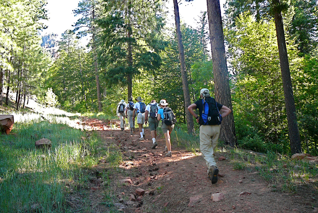
Passage 26 follows the Highline National Recreation Trail for 17 miles and then climbs steeply onto the Mogollon Rim, an impressive escarpment that forms the southern edge of the Colorado Plateau. The route follows well maintained singletrack lined with juniper, manzanita, and oak trees. It crosses numerous drainages, several springs, and passes through forests of aromatic pines and fir trees. It traverses steep sandstone slopes and features spectacular vistas of the Mogollon Rim ahead.
The route leaves the Highline Trail at Washington Park Trailhead and makes a steep climb to the top of the magnificent Mogollon Rim. This marks a significant transition where the AZT leaves the lower-elevation deserts in the south and enters a landscape of pine-clad plateaus to the north. This passage includes numerous access trails and evenly spaced trailheads, which make it ideal for day hiking.
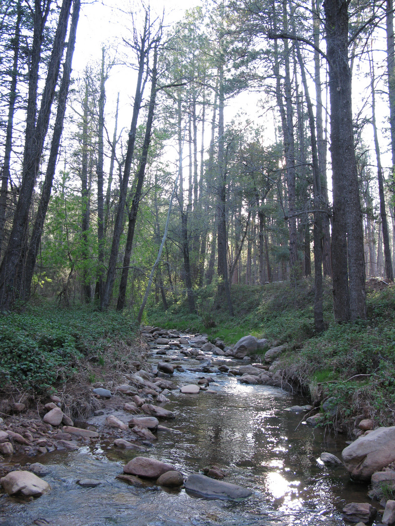
Water may seasonally be found at Red Rock Spring and Pine Spring. It is usually found at Webber Creek, Bray Creek, North Sycamore Creek, and East Verde River. Check the online Arizona Trail Water Report for current information at https://aztrail.org/explore/water-sources/.
Notes/Warnings
All water along this passage should be purified prior to use.
Over 17 miles of this passage follows the well-established Highline Trail in the Tonto National Forest. Designated as a National Recreation Trail in 1979, this historic trail was established in the late 1800’s to link various homesteads and ranches under the Mogollon Rim.
North of Washington Park the trail passes the junction with the Tunnel Trail. The Tunnel Trail leads to what remains of the failed attempt to build a 3,100 foot tunnel through the Mogollon Rim for carrying ore from Globe to Flagstaff.
For more on the Battle of Big Dry Wash, download the January 1931 Arizona Historical Review from http://hdl.handle.net/10150/623320 and see “The Apaches’ Last Stand” by Will C. Barnes, page 36.
The Tonto National Forest is advising thru-hikers and visitors to avoid camping near drainages recently impacted by the Washington Fire along Passage 26 (Highline). This includes 2 miles between Chase Creek (AZT mile 477.1) and the two drainages to the east (mile 479.0). Beware of flash floods, debris flows and other hazards downstream of burned areas!
By Michele Nelson Payson Roundup ~ Saturday's event marked the third year for the Highline Hold’Em mountain bike fundraising ride, and ridership increased by 70%. And that shows how a million-dollar Forest Service investment in the Highline Trail can spur the local economy and increase use of the forest. The Forest Service, the Rim Country Mountain Bike Association and other backers of the event hope to build support for trails of all types to rival the success of TRACKS in the White Mountains, which marshals some 600 volunteers to repair, extend, protect and spread the love for trails there. The White Mountains Trails System includes some 200 miles of interconnected trails, including 67 trails designed mostly for mountain bikers. The TRACKS website includes maps and information on the most popular mountain bike trails. But mostly the event last weekend on the Highline Trail drew a crowd because it's fun, with no pressure to perform. Read the rest of the article here.
By Michele Nelson Payson Roundup ---- The Arizona Trail crosses 19 communities, but only seven will have a four-panel kiosk installed celebrating the trail and the town. Due to connections, Payson will be one of the lucky kiosk communities. “A resident, Trevor Creighton, told the town about this project. Trevor then contacted the mayor as well,” said Interim Parks and Recreation Director JP de la Montagne at the council’s June 28 meeting. When the council understood what Creighton, president of the Rim Country Mountain Biking Association, proposed — that the kiosk was a gift from the Arizona Trail Association through a grant by the Arizona Office of Tourism to Payson – it didn’t take long for the council to accept the gift unanimously. De la Montagne explained the town decided to install the four-panel trail information kiosk at Green Valley Park, as most hikers who come off the AZT enter Payson from Doll Baby Ranch Road and Main Street. Read the rest of the article here.
White Mountain Independent (March 22, 2023) by Michele Nelson Meandering along the face of the 2,000-foot-tall Mogollon Rim, the Highline Trail threads the boundary between ponderosa pine and pinyon juniper forests. The soaring cliffs capture storms, creating springs, drainages and hidden canyons. These storms and the Rim’s geology provide a unique ecological meeting place for plants and animals from the Rocky Mountains to Arizona’s Sky Islands to the south. The Rim reveals layers found in the depths of the Grand Canyon, like Kaibab Limestone and Coconino Sandstone. The limestone makes towering cliffs from ancient sea bottoms, while the red sandstone is the world’s thickest sand-dune-derived sandstone. For too long, this iconic 60-mile-long trail remained neglected. This deterred many hikers from even attempting the Highline. Those captured storms have eroded trails, forcing hikers to hoof it up and down steep slopes and scramble around exposed rocks. Recently, the Forest Service and its partners invested $800,000 to reroute and improve 20 miles of the trail from the Pine Trailhead to the Washington Park Trailhead. Because this stretch is also part of the Arizona Trail, it received support from the Arizona Trail Association. The upgrades have made it accessible to more levels of...
Payson Roundup (December 2, 2022) by Michele Nelson For too long, the Highline Trail has intimidated hikers. Remote. Rugged. Rough. But it’s time for that reputation to change. The Phase I re-route of the Highline Trail from the Pine to the Washington Park trailheads has completely transformed the hike from an out-of-breath scramble to a stroll through glades and meadows and stunning views. Doug Hanson, owner of Cuddy Mountain Trail building company, and side-kick Londen Carpenter spent the last Monday of November finishing up on a contract with the Payson Ranger District. They put the final touches on Phase I of the Highline Trail restoration project. “I’ve been doing this for the past 40 years, worked in 18 states and many national forests. What the Tonto is doing now is top-notch,” said Hanson sitting atop his tiny single track earth-moving machine. Carpenter worked behind to rake the pathway into a well-formed trail ready to stand up to punishing monsoon deluges. Meanwhile, Shawn Redfield, a director for the Arizona Trail Association and a Pine homeowner, used his fold-up saw to chop up an 8-foot tree limb. Redfield spent years mapping out the Highline re-route, hiking and re-hiking sections of the Highline/Arizona...
Payson Roundup (August 11, 2022) by Michele Nelson Arizona Trail Association volunteers recently have prepped 4,000 feet of steep sections of the Highline Trail for realignment as part of the restoration initiative. The removal of dense manzanita not only allows for upgrading and improving the Highline Trail but also Passage 26 of the Arizona Trail. “There were lots of small improvements to get the trail out of problematic drainages, and to reduce the steep grades that led to erosion issues,” said Matthew Nelson, executive director of the AZT Association. “We are focused on the segments that share alignment with the Arizona Trail, from the Pine Trailhead to Washington Park.” For years the Highline Trail languished as an abandoned wagon and cow herding path until the Tonto National Forest partnered with the AZT Association, Pine-Strawberry Fuel Reduction Committee, the Mogollon Sporting Association, Friends of the Tonto National Forest, the MHA Foundation, the National Forest Foundation, Wild Arizona, Arizona State Parks Grants and Trails and Volunteers for Outdoor Arizona to restore and upgrade a trail that passes through stunning landscapes. The resulting initiative has sparked progress toward making “the trail experience better for all,” said Nelson. The AZT Association posts information on...
Payson Roundup (Nov 16, 2021) by Payson Roundup Staff Work is underway to improve the Highline National Recreation Trail (Highline Trail) on the Tonto National Forest. In September 2021, Tonto officials announced plans to improve and re-route portions of the Highline National Recreation Trail (Highline Trail) along with portions of the Arizona National Scenic Trail and trails in the communities of Pine and Strawberry to locations that would make them more sustainable. A collaborative partnership with the Rim Country Trails Working Group identified and developed plans and prioritized trails to improve the environmental condition and user safety for trails on the Tonto. The partnership consists of members from surrounding communities and specialized forest user groups which include Gila County, Arizona Trail Association, Pine Strawberry Fuels Reduction Inc., National Forest Foundation, Wild Arizona, Friends of the Tonto and Volunteers for Outdoor Arizona. To read the article online, click here.
Payson Roundup (May 28, 2021) by Michele Nelson Undaunted, my daughter trudged up the Highline/Arizona Trail from the Pine Trailhead. She walked this same stretch two years and a pandemic century ago — a different person. Brooke solo hiked the 800-mile Arizona Trail after obtaining an undergraduate degree in geology from ASU. She’s working on a master’s degree in geology in Alaska now — reading the dense data in satellite images of the Earth. She hopes to serve the environment, but she’s not sure how. After the long anxiety of the pandemic — she came home for a break between projects. So, we set out on this hike in the footsteps of her memories. It’s been a tough year on all of us, including the forest. As we walked, I made note of the dead snags and the dry dirt after a year with neither a monsoon nor a snowpack. Our hike fell in the late spring of May, wildflower season. But with the region in the grip of an “exceptional” drought, we did not expect to see bursts of wildflower color. But nature likes to gift us in surprising ways. As we headed out from the thinned and tidy...
Anyone who has visited the Highline Passage of the Arizona National Scenic Trail over the past few years will remember the ditch that bisected the trail near Geronimo Spring. The chasm has grown deeper and more dangerous with every storm, creating a significant safety hazard for trail users. Thanks to funding from the State of Arizona and a collaborative effort from Bauer Built Trails, American Conservation Experience, Flagline Trails, Tonto National Forest and the Arizona Trail Association – the problem has been fixed! Using heavy machinery, tons of boulders, downed trees, local soil, ingenuity and determination, the crew removed the old metal culvert that was the source of the problem, backfilled the drainage with rocks, and built fresh tread over the top of it. Despite numerous challenges associated with coronavirus and the strict protocols in place for keeping everyone safe while working outdoors, the small crew worked tirelessly on the project for over one week. The end result is impressive and will be a welcome improvement by all trail users who hike, run or ride along the Highline Passage. When tackling problems like the Geronimo Blowout, the Arizona Trail Association aspires to find a solution that will last 50 years...