


The Coconino National Forest has expanded the boundaries of the existing year-round camping and campfire ban located adjacent to the City of Flagstaff in an attempt to lower the hazard from human-caused wildfires. This information can be located on all Arizona Trail navigational resources, including the FarOut app, topo maps, passage maps, website, and other important resources so AZT users know where they can camp outside the restricted areas. For thru-hikers utilizing the Flagstaff Urban Route (Passage 33), the longest distance to cover is 13.5 miles – from Flagstaff to Snowbowl Road. Section hikers have much greater distances to cover to avoid the camping ban area, especially along Passages 32 and 34. In addition to addressing the immediate concern for future large human-caused wildfires, the expansion is part of a long-term risk reduction strategy focused on forest health and resiliency. The change was made in response to public feedback, with support from the Arizona Trail Association. If you're planning multi-day trips on the AZT near Flagstaff, please be aware of where you can and cannot camp.
Read More
Location
- Marshall Lake Trailhead to Interstate 40
Length
- 20.8 miles
Resources
- MAP
- PROFILE
- TRACK
- Waypoints: GPS | MP
- Arizona Euro-American History
- USGS Topographic Maps: Lower Lake Mary, Flagstaff East and Winona.
- Coconino National Forest – Visitors Guide.
- Coconino National Forest – Recreational Opportunity Guide.
- Coconino National Forest map.
- BLM Information Center maps.
Southern Trailhead: Marshall Lake Trailhead
- GPS Coordinates: 35.11125° N, 111.54138° W
Access
From Flagstaff, take the Lake Mary Road exit (339) off I-17 for 9 miles, then turn left (east) on FR 128 at the sign for Marshall Lake. Pass the observatory turnoff, then at 2.2 miles turn left before Marshall Lake (more of a marsh) and park at the AZT sign on the left. If you are coming from the south on Lake Mary Road, the Marshall Lake turnoff is 7.5 miles north of Pine Grove Campground.
Northern Access Point: I-40, Cosnino Road Exit
GPS Coordinates: 35.20249° N, 111.48559° W Note: this point is located across a private property boundary from the I-40 frontage road. No parking is allowed along the frontage road.
Access
Currently, there is not direct access to the Northern boundary of this passage. The closest access to the south 4 miles south at Old Walnut Canyon Road: From Flagstaff, follow I-40 east and take exit 204 toward Walnut Canyon. Follow the paved Walnut Canyon Road (FR 622) south for 2.5 mi to Old Walnut Canyon Rd (FR 303). Turn right. The trailhead is about 1.7 mi west on the left (south) side of the road. There is room for horse trailers.
Trail Route Description
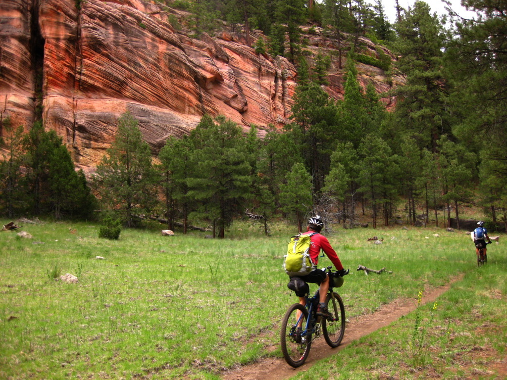
Passage 31 connects Marshall Lake and Walnut Canyon. This section follows singletrack across a gently rolling terrain through pine and oak forest before descending steeply into Lower Walnut Canyon. It passes by interesting red rock cliffs and features impressive vistas with stunning views of the San Francisco Peaks. This section also includes an opportunity to take an alternate trail into the town of Flagstaff – Passage 33 (Flagstaff Urban Route).
In the bottom of Sandy’s Canyon, before the AZT ascends to Fisher Point, the trail comes to a junction where the AZT splits. The fork to the northwest is a resupply route for thru-hikers, heads north into Flagstaff (see Passage 33). The fork to the northeast ascends towards Fisher Point, and then follows the edge of Walnut Canyon.
Difficulty
- Moderate
Season(s)
- Spring, Summer and Fall
- Current weather forecast
Water
There are reliable water sources on this passage at the two wildlife water tanks. There is water in the city of Flagstaff and in Walnut Canyon National Monument. Check the online Arizona Trail Water Report for current information at https://aztrail.org/explore/water-sources/.
Notes/Warnings
- All water along this passage should be purified prior to use.
For more information
- The Passage Steward
- Coconino National Forest, Flagstaff Ranger District, 5075 N. Hwy 89, Flagstaff, AZ 86004 (928) 526-0866.
- Walnut Canyon National Monument 6400 N. Hwy 89, Flagstaff, AZ 86004 (928) 526-3367.
- BLM Information Center (602) 417-9300.
Current Passage Info

Walnut Canyon Reroute Complete
October 14, 2022
The recently completed Walnut Canyon Reroute is officially open! This important initiative to take a few miles of the AZT off old forest roads south of Flagstaff, was a successful collaboration between the Arizona Trail Association, Coconino National Forest, Arizona Conservation Corps, Arizona State Parks & Trails, Flagline Trails, and awesome volunteers. If you haven’t experienced this new ribbon of trail between Fisher Point and Old Walnut Canyon Road Trailhead, get out there and enjoy it on foot, mountain bike or equine. We are proud that this one of the first high priority recommendations from the Flagstaff Trails Initiative Regional Trail Strategy to be implemented! Matt Roberts and Kevin Okon of Flagline Trails used a combination of mini-dozer and mini-excavator to rough in the new singletrack. They worked alongside Arizona Conservation Corps to make the tread absolutely perfect, and obliterated and naturalized 0.65-mile of old trail. Unless you look carefully, you’ll never notice there used to be road and trail there! ATA staff and volunteers then finished nearly a mile of trail with hand tools at a volunteer event in August. The Flagline Trails crew returned to finish the rest of the tread, major brushing and closed the old trail...
Read More
