


Outside Online (April 23, 2024) by Graham Averill Base camp might be my favorite two words in the English language. Base camp is where you stage the next excursion, or refuel with a bowl of stew, or a beer. You rest and recover there. If you’re lucky, you can slip into a hot tub or cold spring, because base camps don’t always have to be a tent or in the back of your truck. Sometimes, base camp can be a lodge with soft sheets and a chef. I’ve gathered a handful of my personal favorite adventure lodges and picked a few more destination hotels and chalets on my bucket list. Some of them are high-end and worthy of a splurge, while others are downright affordable. All of them are chosen specifically for their locations and adventures they offer, putting visitors within reach of dramatic landscapes while providing gear, know-how, and sometimes in-house guides. Because occasionally it’s nice not to have to plan everything yourself. The Gravel House Hotel, Patagonia, Arizona You may not have heard of Patagonia, Arizona, a tiny town of 800-ish sitting at the base of the Patagonia Mountains, near the Mexico border. Much of the surrounding land is...
Read More

Location
- Highway 82 to Apache Springs Trailhead
Length
- 20.9 miles
Resources
- MAP
- PROFILE
- TRACK
- Waypoints: GPS | MP
- Arizona Euro-American History
- Casa Blanca Canyons Trail Map & Guide.
- USGS Topographic Maps: Patagonia, Mount Hughes and Mount Wrightson.
- Coronado National Forest map.
- BLM Information Center maps.
Southern Access Point: Casa Blanca Canyon Trailhead
- GPS Coordinates: 31°36’1.23″N, 110°43’26.83″W
Access
From the north, follow Highway 82 toward the town of Patagonia. Four miles north of town, turn right/west on Casa Blanca Canyon Road. Follow this dirt road west for 1/4-mile and look for the trailhead on your left/south. Park here, walk through the AZT gate, and follow the Connector Trail for 1/3-mile to locate the Arizona Trail. There is no parking or access along Highway 82; instead please use the Casa Blanca Canyon Trailhead nearby.
Northern Access Point: Apache Springs Trailhead
- GPS Coordinates: 31.71873° N, 110.75704° W
Access
From Sonoita, follow AZ 83 north 4 miles and turn left (west) onto Gardner Canyon Road (FR 92). Avoid side roads. You’ll reach the Apache Springs Trailhead 5.5 miles from the highway on the right side of the road. There is a large parking area here.
Trail Route Description
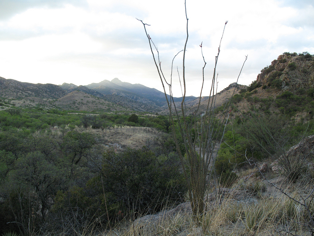
Passage 4 begins with a long ascent into the Santa Rita Mountains, a rugged sky island range with steep slopes and granite peaks. The Tohono O’odham call this mountain range Ce:wi Duag (Long Mountain). This passage features incredible biodiversity and is home to rare birds and some plants that occur nowhere else in the United States. Mt Wrightson, the high point of the Santa Rita Mountains, rises to an elevation of 9,453 feet and has a distinctive pyramid peak that can be seen throughout much of Baja Arizona. Trail users may follow connector trails on the Coronado National Forest to reach this iconic summit.
Starting from the Casa Blanca Canyon Trailhead, this section begins in a grassland ecosystem and climbs through oak savannah to reach the sweet smelling oak-pine forest on the edge of the wilderness. Early in spring, it is not uncommon for snow to remain on the higher peaks and hillsides.
This passage features some of the most recently built miles of the AZT. After decades of sharing alignment with dirt roads north of the town of Patagonia, the Temporal Gulch Reroute Project improved safety for trail users and provides a National Scenic Trail experience through construction of 31 miles of trail.
Difficulty
- Moderate
Season(s)
- Fall, Winter and Spring
- Current weather forecast
Water
Water is intermittent and scarce. Plan to bring your own water. Check the online Arizona Trail Water Report for current information at https://aztrail.org/explore/water-sources/.
Notes/Warnings:
- To reach the town of Patagonia, use the Train Track Trail that runs parallel to Hwy 82. This four-mile connector trail will take you from the AZT at Hwy 82 and Casa Blanca Canyon to the Patagonia Post Office.
- Trail work is not permitted June 15- October 1 due to threatened & endangered species that live within the area.
- The southern portion of this passage experiences extreme overgrowth in the summertime. Expect difficult route finding, wear long protective layers, and be prepared for extreme conditions if you’re on the trail in the summer and early autumn months.
- WARNING: If you choose to hike or ride on Harshaw Road to reach the town of Patagonia, beware of mining truck traffic. Use extreme caution when driving on Harshaw Road. Hikers and mountain bikers should travel as far off the roadway as possible, and equestrians should consider avoiding this area entirely.
- All water along this passage should be purified prior to use.
- Mountain bikes are prohibited in the Mt. Wrightson Wilderness.
For more information
- The Passage Steward
- Coronado National Forest; Zach MacDonald; (520) 428-0062; Nogales Ranger District; 303 Old Tucson Rd., Nogales, AZ 85621
- BLM Information Center (602) 417-9300.
Current Passage Info

Support the Temporal Gulch Reroute Project
March 22, 2021
Your support is needed to help us reach our fundraising goal this Spring to support construction of the Temporal Gulch Reroute Project. Please DONATE securely online today! Our goal is to raise enough money between March 22 - April 3 to sustain the next phase of trail construction. This project will remove the AZT from 17 miles of paved and dirt roads near the town of Patagonia with 32 miles of sustainable singletrack. This improvement will make the Arizona Trail safer, more scenic, and will be our largest trail construction project in recent history. Whether you hike, run, pedal or ride, we can't wait for you to experience the AZT through the Casa Blanca Canyons with Mt. Wrightson towering in the background! Please donate today and encourage your trail loving friends to do the same. Donors giving $25 or more will receive a limited-edition sticker in the mail as a small token of thanks.
Read More

Trail Construction Near Patagonia Commences
May 14, 2020
Trail construction on the 32-mile Temporal Gulch Reroute Project has begun! A crew of four American Conservation Experience trail professionals and a mini-excavator operator – Rob Bauer of Bauer Built Trails – have been hard at work building singletrack in the Canelo Hills. Watch this 30-second time-lapse video for a snapshot of what they’re up to. Once completed, this project will replace paved and dirt roads with sublime trail. Want to help? Donations are the best way to ensure this project keeps moving forward, and we’ll be doing outreach for volunteer labor later this year.
Read More
