


The Coronado National Forest, Pima County, and Arizona Trail Association have announced a temporary detour of the Arizona National Scenic Trail (AZT) near the community of Summerhaven due to a construction project at the Marshall Gulch Trailhead. This detour will go into effect immediately and will remain in place until August 1, 2026. This impacts AZT Passages 11 (Santa Catalina Mountains), 12 (Red Ridge), and the Pusch Ridge Wilderness Bypass. For those hiking northbound: From Marshall Saddle at FarOut NOBO mile 181.6 do NOT follow Marshall Gulch Trail. Instead, follow Mint Spring Trail to E Carter Canyon Rd. Turn right on E Carter Canyon Rd and hike to N Sabino Canyon Pkwy. Turn left on N Sabino Canyon Pkwy and rejoin the AZT in the town of Summerhaven. See map here. For those hiking southbound: From the intersection of N Sabino Canyon Pkwy and E Carter Canyon Rd in Summerhaven at FarOut SOBO mile 613.6, do NOT continue on N Sabino Canyon Pkwy. Instead turn right on E Carter Canyon Rd and follow to the Mint Spring Trail. Turn left on Mint Spring Trail and follow until rejoining with the AZT at Marshall Saddle and the Wilderness of Rocks Trail....
Read More
Location
- Gordon Hirabayashi Trailhead to Oracle Ridge Trailhead
Length
- 21.6 miles
Resources
- MAP
- PROFILE
- TRACK
- Waypoints: GPS | MP
- USGS Topographic Maps: Agua Caliente Hill, Sabino Canyon and Mount Lemmon.
- Coronado National Forest map.
- BLM Information Center maps.
Southern Trailhead: Gordon Hirabayashi Trailhead
- GPS Coordinates: 32.33581° N, 110.71972° W
Access
Follow Tanque Verde Road east from Tucson and turn left (north) on the Catalina Highway. Drive about 9 miles and pass Molino Basin Campground. Continue 1.7 miles beyond the campground and take the left (west) turn to Gordon Hirabayashi Campground. Drive 0.3 miles to a parking area. Follow a trail out of the south end of the parking lot for 40 yards to reach a “T” intersection with the AZT.
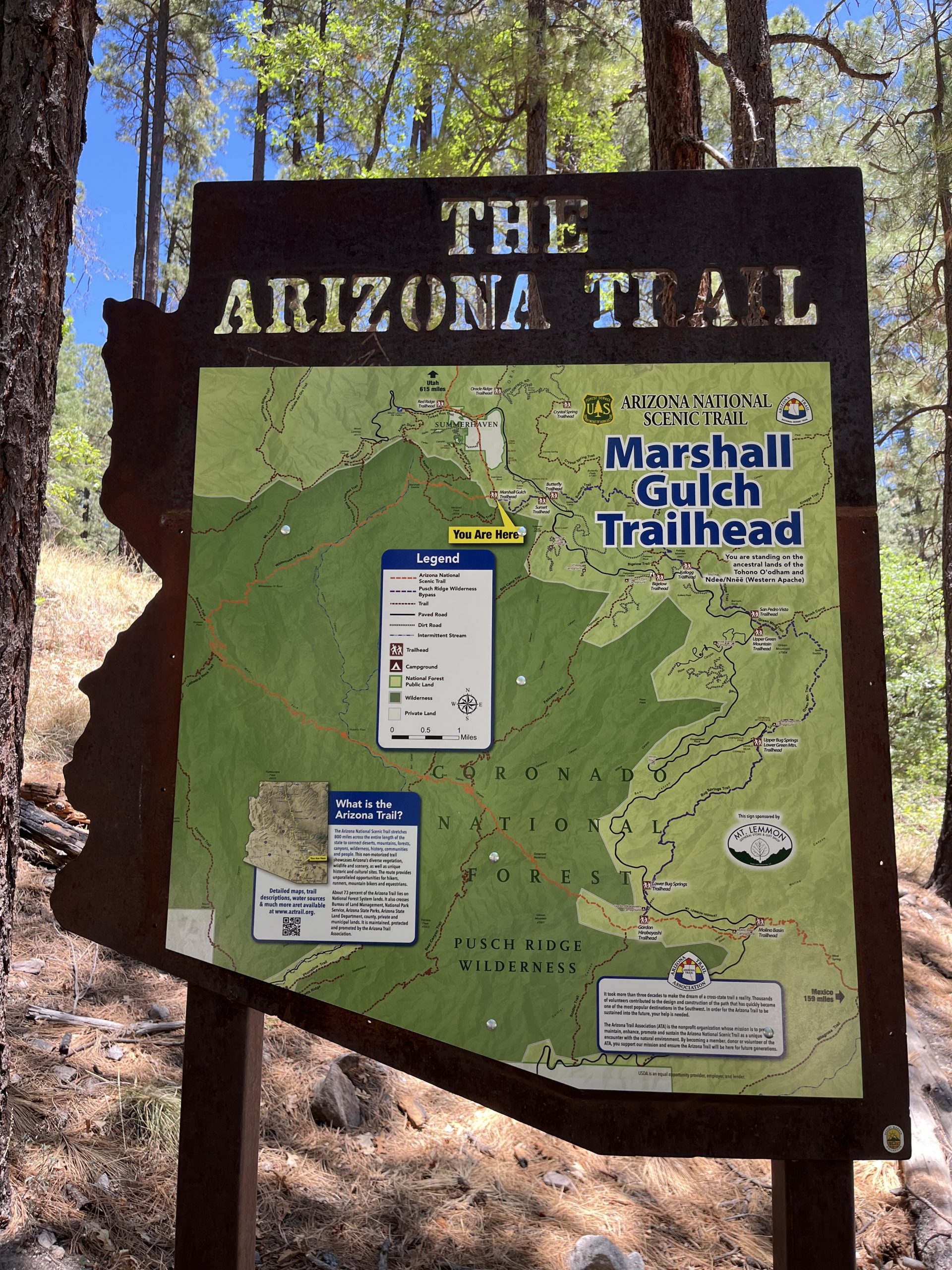
Northern Trailhead: Summerhaven
- GPS Coordinates: 32.44653° N, 110.75825° W
Access
From Tucson, head north on Catalina Highway high into the Santa Catalina Mountains toward the town of Summerhaven. After passing Loma Linda Picnic Area and at the road to Mt. Lemmon Ski Valley.
Trail Route Description
The Pusch Ridge Wilderness Bypass is an alternate route for trail users to avoid the designated wilderness area within Passage 11 (ideal for hikers, but illegal for mountain bikers and very dangerous for equestrians). The ATA strongly recommends this route for equestrians so they can avoid the difficult northern section of Passage 11 (Santa Catalina Mountains). This bypass is a very technical route, but safer than Passage 11 for equestrians.
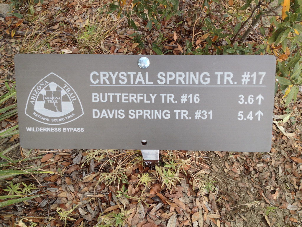
From the Gordon Hirabayashi Trailhead the route crosses Catalina Highway and then follows Bug Springs Trail, Green Mountain Trail, Incinerator Ridge Trail, and then on the Butterfly Trail. It joins the Crystal Spring Trail which ends on the Control Road. This road takes you to the Oracle Ridge Trailhead and the end of the bypass.
Difficulty
- Moderate to Difficult
Season(s)
All year. Snow can be present at higher elevations after winter storms and lower elevations can be quite warm in summer (current weather forecast)
Water
Water may be found at Novio Spring, Crystal Spring, and Green Spring.
Notes/Warnings
- All water along this passage should be purified prior to use.
For more information
- The Passage Steward
- Coronado National Forest, Santa Catalina Ranger District, 5700 N. Sabino Canyon Rd., Tucson, AZ 85715 (520) 749-8700.
- BLM Information Center (602) 417-9300.
Current Passage Info

Coronado National Forest Releases Santa Catalina Trail Plan
June 23, 2023
After 18 months of hard work, our partners at the Coronado National Forest have released the first comprehensive trail plan for the Santa Catalina Ranger District, which includes the northern slope of the Rincon Mountains, Mount Lemmon, Summerhaven and Oracle Ridge. According to Adam Milnor, Recreation, Heritage and Lands Staff Officer for the Forest, the plan includes projects to "diversify trail opportunities, improve sustainability, create new trail connections and boost trailhead access" on the district. A number of the proposed projects will impact Passages 9-12 of the Arizona National Scenic Trail, addressing long standing issues with this well-loved portion of the Trail. These aspirations aren't just dreams, either. Thanks to the recent flow of federal funding from sources such as the Great American Outdoors Act, or GAOA, many of these projects may become reality starting as soon as this winter. The ATA joined the Southern Arizona outdoor recreation community and other trail organizations such as the National Forest Foundation, Tucson Off Road Cyclists and Activists, Santa Catalina Volunteer Patrol, Pima County, Friends of the Santa Catalina Trails and others to help Forest Service staff shape the plan - and we will continue to be involved in it's implementation. ATA volunteers...
Read More
