


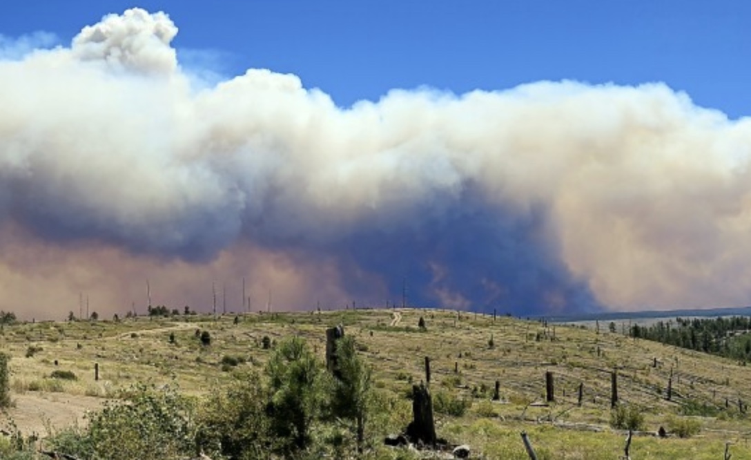
The Rock Canyon Fire began Monday afternoon after a lightning strike near the Arizona-Utah border on lands managed by the Bureau of Land Management (Arizona Strip Field Office). Extreme heat and drought conditions, combined with high winds, have seen the blaze grow to nearly 3,000 acres overnight. Currently, the fire is only 5% contained. In the interest of public safety, the BLM and Kaibab National Forest have closed 19 miles of the Arizona Trail between the Navajo Trail junction and Stateline Trailhead -- the northern terminus of the Arizona National Scenic Trail. Please avoid this area until the fire is contained and it has been determined to be safe for visitation. For up-to-date information, rely on Watch Duty.
Read More
Location
- Orderville Trailhead to Winter Road Trailhead
Length
- 17.1 miles
Resources
- MAP
- PROFILE
- TRACK
- Waypoints: GPS | MP
- Arizona Euro-American History
- USGS Topographic Maps: Jacob Lake, Cooper Ridge, Buck Pasture Canyon and Coyote Buttes.
- Kaibab National Forest map.
- BLM Information Center maps.
Southern Trailhead: Orderville Trailhead
- GPS Coordinates: 36.73646° N, 112.18889° W
Access
From Jacob Lake, head east on US 89A for 2.2 miles, then turn right (south) on FR 205. The trailhead is on the left in 50 yards.
Northern Access Point: Winter Road Trailhead
- GPS Coordinates: 36.91780° N, 112.10705° W
Access
From US 89A, at House Rock Road, 13.7 miles east of Jacob Lake, turn north on House Rock Road for 15.6 miles to Winter Road (BLM Road 1025). Turn left (west) on Winter Road for 3.7 miles to the AZT, where a large metal AZT sign indicates the trailhead.
Trail Route Description

Passage 42 continues north across the Kaibab National Forest, following a downhill grade. Descending from the Kaibab Plateau to the Great Basin Conifer Woodland, the landscape changes from ponderosa pine forest to a high desert landscape covered in red dirt, big sagebrush, juniper trees, and creeping prickly pear. This section marks the final major ecosystem change along the entire AZT.
Difficulty
- Easy to Moderate
Season(s)
- Spring, Summer and Fall
- Current weather forecast
Water
There are seasonal and almost probable water sources on this part of the Kaibab Plateau. The is a good water source at the end of the passage. Check the online Arizona Trail Water Report for current information at https://aztrail.org/explore/water-sources/.
Notes/Warnings
- All water along this passage should be purified prior to use.
- The Arizona Trail is marked with brown fiberglass posts with a Kaibab Plateau Trail decal near the top.
For more information
- The Passage Steward
- Kaibab National Forest, North Kaibab Ranger District, P.O. Box 248, Fredonia, AZ 86022 (928) 643-7298.
- Kaibab Plateau Visitor Center, Jacob Lake, AZ (928) 643-7298.
- BLM Information Center (602) 417-9300.
Current Passage Info

Mangum Fire Detour is Now Fresh Trail
September 2, 2022
During the summer of 2020, the Mangum Fire scorched 71,450 acres on the Kaibab National Forest and significantly impacted three miles of the Arizona Trail within Orderville Canyon along Passage 42 (Kaibab Plateau North). Since the trail was located within the canyon bottom and the fire burned at high intensity, this segment of AZT has been closed for two years in the interest of public safety. Trail users have been rerouted along forest roads through blackened forest nearby. But thanks to the hard work of Arizona Trail Association volunteers and staff, and our friends at Flagline Trails and the Kaibab National Forest, fresh new trail has recently been built upslope from the drainage, which is a far more sustainable location. We couldn’t be happier about this project, especially since we thought it would take four to five years for the hillsides to naturally stabilize after such a high-severity fire. While know dead trees will continue to fall and the new trail will require frequent maintenance, being able to reopen this piece of trail and keep trail users off forest roads is a grand accomplishment. The ATA is grateful for everyone who has worked so hard to make this happen, especially...
Read More
