USGS Topographic Maps: Montezuma Pass, Miller Peak and Huachuca Peak.
Coronado National Forest Map, Sierra Vista Ranger District.
BLM Information Center maps.
“Trails of the Huachucas” by Leonard Taylor.
Southern Terminus: Mexico Border
GPS Coordinates: 31.33367° N, 110.28276° W
NOTE: This trailhead is not directly accessible by vehicles. Montezuma Pass is 1.8 miles north at 31.35112° N, 110.28527° W and is the nearest practical access.
Access
This passage is unique because you must start at mile 1.8 at Montezuma Pass and hike south in order to get to the beginning of the passage. To reach Montezuma Pass from the town of Sonoita, follow AZ 83 south 30 miles to its intersection with FR 48. Turn left (south) onto FR 48 and continue 5.4 miles to FR 61. Continue east 8.8 miles on a rough dirt road to a large parking area at the summit of the pass.
From Sierra Vista, travel 14 miles south on AZ 92 and turn right (south) on S. Coronado Memorial Road. Continue 8.3 miles, generally south and west, to the large parking area at the summit of the pass. Shortly after you pass the Coronado Memorial Visitor Center, the road turns to dirt and climbs to the pass via switchbacks. This road is narrow and curvy and is subject to vehicle trailer restrictions (24 ft.). Contact the Coronado National Memorial for more information.
Northern Trailhead: Parker Canyon Lake Trailhead
GPS Coordinates: 31.41946° N, 110.44206° W
Access: From the town of Sonoita, follow AZ 83 south 30 miles to its intersection with FR 48. Turn left (south) onto FR 48, continue 0.5 miles, and turn right onto South Lake Drive. Proceed 0.5 miles and follow signs to a dirt parking area near the AZT kiosk.
Trail Route Description
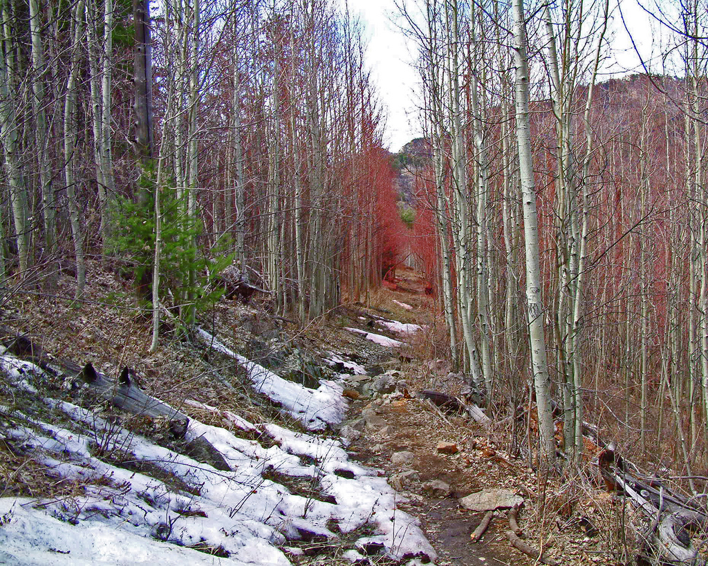
Passage 1 begins with a climb from the Mexico-U.S. border. This section takes you from grasslands to snow through a variety of temperatures and environments. You will travel through Coronado National Forest, up the spine of the Huachuca Mountains, and onto the first of several unique landforms known as “sky islands.” This term refers to an isolated mountain range that rises several thousand feet above the desert floor, resulting in dramatically different life zones from top to bottom. These mountain ranges become habitat islands that are separated from each other by the surrounding “sea” of desert.
This remote section is not easily accessible and requires an out-and-back hike from Montezuma Pass just to reach the official start of the trail at the border (adding 1.8 miles to the total distance).
At the southernmost point you have cholla cactus, agaves and expansive views of the San Rafael Valley – a unique Sonoran grassland environment. Your ascent continues along a rocky singletrack trail into the Huachuca Mountains, which are rich in cultural history, biodiversity, and inspiring views into Mexico’s northern state of Sonora.
The trail gains over 3,000 feet within the first six miles traveling from desert grassland to a conifer forest filled with fragrant ponderosa pines and Douglas fir trees. Here, in the higher elevations, it is not uncommon for snow to remain on the ground well into the spring months.
The trail continues to rise and fall for several miles across the high ridges of the mountains, before lowering into Sunnyside Canyon. From pine cones to prickly plants the trail now descends over 3,000 feet, and continues north towards Parker Canyon Lake and the end of this passage.
This first passage beautifully displays the pristine nature and unique biodiversity that defines the Arizona National Scenic Trail (AZT).
Water should be found at Tub Spring (aka Bathtub Spring), Bear Spring, and Parker Canyon Lake (seasonal store; always lake). Seasonal water may be present in Sunnyside and Scotia Canyons. Check the online Arizona Trail Water Report for current information at https://aztrail.org/explore/water-sources/.
Notes/Warnings
This area can be hot and dry. Bring plenty of water. All water along this passage should be purified prior to use.
Most of this passage is located within the Miller Peak Wilderness and Coronado National Memorial. Motorized and mechanized vehicles and equipment, including mountain bikes, are not permitted on the Memorial’s trails nor in the Wilderness.
Transportation is available from the Tucson airport to the Coronado National Memorial Visitor’s Center and Montezuma Pass from a variety of shuttle operators. Please visit the Shuttles page for more information.
Before using this trail, call for a report on current trail conditions which can vary with season, weather and maintenance status.
Dogs are not allowed on the southernmost 1.8 miles of the Arizona Trail within Coronado National Memorial (Coronado Peak, Joe’s Canyon and Yaqui Ridge Trails).
Overnight parking is allowed at Montezuma Pass as long as the driver does not occupy the vehicle overnight (no car camping).
For long-term parking, please contact Sierra Vista Self Storage (520-458-4400). They offer secure parking not far from the AZT’s southern terminus for $40/month.
Horses are not allowed on the southernmost 1.8 miles of the Arizona Trail within Coronado National Memorial (Coronado Peak, Joe’s Canyon and Yaqui Ridge Trails). Equestrians should instead use forest roads from Border Monument 103 to Montezuma Pass Road and then rejoin the AZT at Montezuma Pass.
Arizona Republic (April 22, 2026) by Joan Meiners One week before Earth Day, on April 15, the Department of Homeland Security convened a Zoom call with the Arizona Trail Association to explain that the agency had ordered the southernmost mile of the Arizona National Scenic Trail closed so that contractors could blast and grade the earth through Coronado National Memorial to make way for a double-layered border wall. The trail may reopen in late 2027 at the junction of Yaqui Ridge Trail and Joe's Canyon Trail, according to estimates from Trump administration officials. Hikers could then continue toward the southern terminus of the approximately 800-mile trail stretching between Utah and Mexico — but only to within about 500 feet of the second barrier. With no specific design plan released, the total area of impact within the national park site is not yet clear. Beyond that buffer, civilians will not be allowed to approach the border in this region, which the administration announced in November will now be marked by two rows of 30-foot-high steel barriers separated by a 150-foot-wide road for patrol vehicles and security personnel. And trail sojourners will never again have access to border monument 102, which has served...
AZPM (April 18, 2026) by Angela Gervasi A segment of the Arizona Trail is now closed to the public as border fence construction continues along the state’s southeastern edge. In a social media post Monday, the National Park Service said the closure was necessary to “ensure visitor safety” amid construction and blasting activity in the area. The closure, which applies to the trail’s southernmost mile, will likely last through the end of 2027, according to the Arizona Trail Association, a Tucson-based nonprofit. “We knew this was going to happen at some point, especially under this administration,” Matthew Nelson, the association’s executive director, told AZPM this week. Last year, the Department of Homeland Securityawarded nearly $310 million to Fisher Sand & Gravel Company to build 27 miles of new border fence in southeastern Arizona. Since then, construction has crept through the area — particularly the San Rafael Valley, where an initial 30-foot-tall steel bollard was erected last September. By March, contractors had established about five miles of new border fence, according to an estimate from the Center for Biological Diversity. The southernmost stretch of the Arizona Trail runs through the Huachuca Mountains — west of the San Rafael Valley — and...
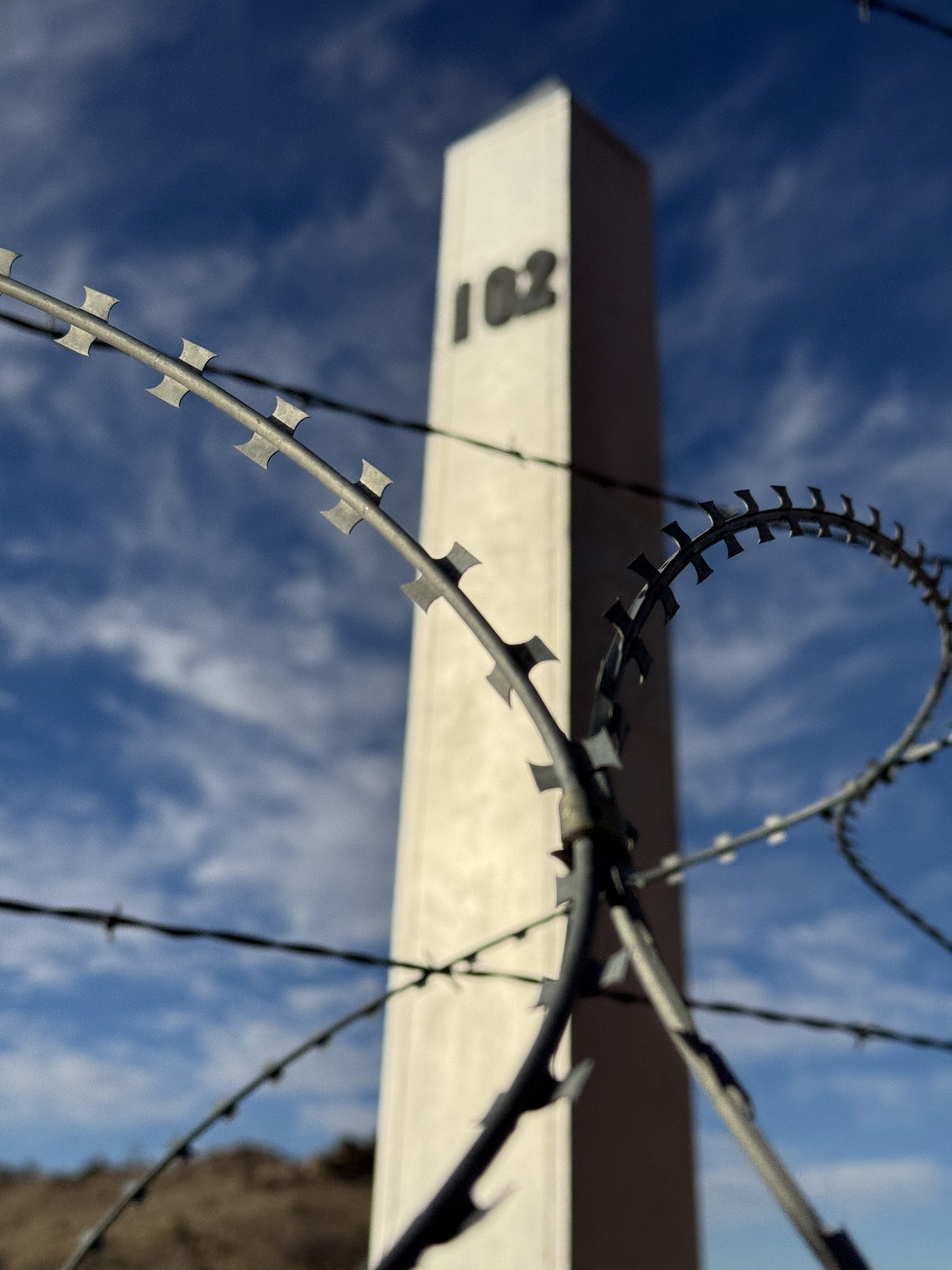
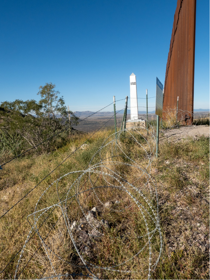
GearJunkie (April 14, 2026) by Mary Andino The 800-mile Arizona Trail (AZT) is a premier thru-hike. It’s one of only 11 specially designated National Scenic Trails, and hundreds of people complete it every year. Now, however, it will be obstructed, and hikers will be unable to traverse its entire length. Recent border wall construction has blocked access to the final mile of the Arizona Trail (AZT). This is the most recent example in a long-running trend of efforts to increase border security and limit public lands access. What’s Happening Like all thru-hikes, the start and end of the AZT has dedicated termini. Typically, hikers will take the opportunity for a photo-op there and celebrate finishing or starting their hike. For the Arizona Trail, it’s Border Monument 102. This shiny, steel obelisk is on National Park Service (NPS) land within Coronado National Memorial. It demarcates the U.S.-Mexico border and the trail’s southern terminus. Hikers have faced issues accessing the terminus since 2020. According to Arizona Trail Association (ATA) Executive Director Matthew Nelson, in late 2020, the Trump Administration began building a wall near the monument, temporarily blocking hiker access. “We saw the construction of 420 feet of border wall right at the southern terminus. And...
Beginning Monday, April 13, the Arizona National Scenic Trail is closed between the southern terminus at Border Monument 102 and the Joe's Canyon Trail junction at mile 1.0. Due to construction activities associated with Dept. of Homeland Security's border wall within Coronado National Memorial, the southernmost mile of the AZT is closed until further notice (likely through the end of 2027). Current plans include construction of two 30-foot-tall steel barriers, with a 150-foot-wide road in between. Visitors are warned not to hike on the AZT (Yaqui Ridge Trail) south of Joe's Canyon until the closure is rescinded. The Arizona Trail Association is working with National Park Service staff to develop a southern terminus monument on Coronado Peak, just south of Montezuma Pass. This location has outstanding views of the San Rafael Valley, is far away from construction activities and border wall impacts, and is the exact location where Dale Shewalter ("The Father of the Arizona Trail") first had a vision for the Arizona Trail in the 1970s. Check out this article from GearJunkie, published on April 14.
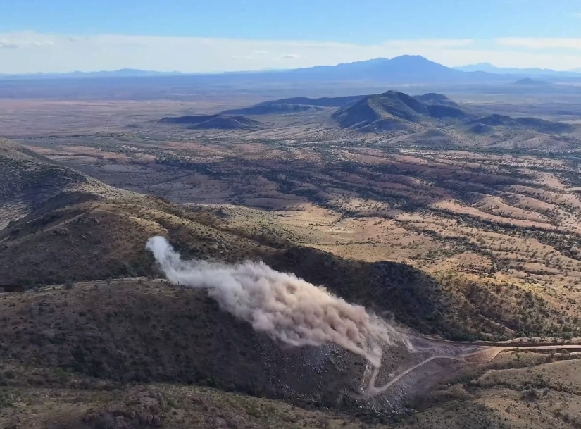
Customs and Border Protection just announced that the next round of detonations within the Huachuca Mountains will occur on March 25 from 11 am to 5 pm. The blast site is located 1,500 feet west of the southern terminus of the Arizona National Scenic Trail on lands managed by the Coronado National Forest. While the Arizona Trail is out of the immediate zone of impact and there is no threat from flying debris, visitors to Coronado National Memorial's Montezuma Pass and the Arizona Trail (aka Yaqui Ridge Trail) are warned of impacts to scenery and natural quiet during these operations. We expect closures of the AZT to be announced in April as road improvements and wall construction are anticipated at this location within the next few weeks. Springtime thru-hikers are unlikely to be able to access Border Monument 102 and the southernmost mile of the Arizona National Scenic Trail once closures are implemented.
SFGATE (FEb 18, 2026) by Amanda Heidt It was a cool, breezy morning in early December when Myles Traphagen, the borderlands program coordinator for the conservation nonprofit Wildlands Network, joined a handful of people atop Coronado Peak in Arizona. Less than a mile from the U.S.-Mexico border, the mountain lies within Coronado National Memorial, a 5,000-acre stub of public land marking the valley where Spanish conquistador Francisco Vásquez de Coronado first entered what is today the United States in 1540 seeking the mythical Seven Cities of Cíbola. Centuries later, Traphagen’s own expedition watched as a line of armored trucks wended its way along a dirt road far below. At 3 o’clock that afternoon, the dynamite those trucks had delivered detonated, blasting a trench deep into the mountain’s foothills — the beginnings of a new stretch of double border wall that, under the current administration, may one day expand to cover all 2,000 miles of border running from California to Texas. Traphagen and his companions were there to bear witness to what they say is an increasingly common, and extremely troubling, phenomenon: the co-opting and destruction of public lands along the southern border with little oversight. SFGATE could find no evidence of environmental impact reports, cultural or...
YouTube (Feb 8, 2026) by Eric Hanson The Arizona Trail is one of the most iconic long trails in the country, as it runs 800 miles from The US - Mexico border up to Utah. For any thru-hiker, hiking the Grand Canyon State is an incredible achievement. But as of January 2026, construction resumed along the border in the Huachuca Mountains, one of the most rugged stretches of the 2,000-mile-long border. The wall will wreak havoc on vital wildlife corridors, destabilize water tables, and heavily affect the border communities. But the Department of Homeland Security issued waivers for more than 40 environmental laws in order to build the wall. I wanted to hike this final stretch of trail before the southern terminus at Monument 102 was closed behind the border wall forever. Watch the video here.
In November 2025, contractors for the Department of Homeland Security installed concertina wire at the U.S./Mexico border at the southern terminus of the Arizona National Scenic Trail. This prevents trail users from accessing Border Monument 102 -- the traditional "start" or "finish" of the AZT. In the interest of safety, please do not attempt to cross the wire for a photo at the monument. Border wall construction activities continue west of Coronado National Memorial, including blasting to make gravel for concrete. Additional steel wall construction is not planned at the Arizona Trail's southern terminus until August of 2026, where trail closures may be necessary to protect trail users from construction activities. Please check back for updates.
Arizona Republic (June 20, 2025) by Raphael Romero Ruiz U.S. Customs and Border Protection awarded more than $309 million to Fisher Sand and Gravel Co. to build 27 miles of border wall in Arizona's Tucson Sector. This is the second contract for border wall construction awarded since President Donald Trump’s return to the White House. The new project will use funds from a 2021 congressional appropriation to “close critical openings in the border wall" following the halt of border wall construction under former President Joe Biden, the CBP announced June 18. The federal government will pay Fisher Sand and Gravel Co., a North Dakota-based company, $309,463,000 over the next two and a half years. The construction company, a family business operated by Tommy Fisher, is a well-known fixture of border wall construction in the Southwest. During the first Trump administration, Fisher's company was tapped to build many projects across the Arizona-Mexico border as well as in New Mexico and Texas, landing approximately $2 billion in wall contracts. "Continuing border wall construction in Tucson will support the Department of Homeland Security’s ability to impede and deny illegal border crossings and the drug and human smuggling activities of transnational criminal organizations," the federal agency...
Tucson Sentinel (June 5, 2025) by Paul Ingram As the Trump administration plans to erect 35 miles of new border barriers, environmentalists gathered last weekend in a Southern Arizona hamlet to trade food and songs during a bi-national "border happening." Under the shade of large, decades-old cottonwood trees, a man from the nearby village of Santa Cruz, Sonora, played a guitar to an adoring crowd and carne asada smoldered on a grill as hundreds turned out on Saturday in the village of Lochiel to protest a plan to build a border wall through the San Rafael Valley. For weeks, environmentalists on both sides of the border have worried about federal plans to carve a new border wall through the valley, effectively sealing up protected grasslands in one of the few areas without a border barrier. In April, officials with U.S Customs and Border Protection laid out a plan to build 24.7 miles of new border wall. On Thursday, Homeland Security Secretary Kristi Noem set this in motion, waiving dozens of environmental laws to build a significantly larger stretch, extending 35 miles along the Arizona-Mexico border. In a document published to the federal register, Noem waived federal laws for two new sections: one...
Patheos (April 6, 2024) by Ken Chitwood In February 2019, Miguel stared out at the San Pedro Valley in Mexico, stretching for miles below him from his position on Yaqui Ridge in the Coronado National Monument. Standing at Monument 102, which marks the symbolic start of the 800-mile-long Arizona Trail, Miguel remarked on how the border here doesn’t look like what most people imagine. Instead of 30-foot bollards, all one finds is mangled barbed wire to mark the divide between Arizona and Sonora. Here hikers can dip through a hole in the fence to cross into Mexico, take their selfie, and pop back over. “It’s as easy as that,” Miguel said, with a melancholic chuckle. But for Miguel’s mother the crossing was not only difficult — it was deadly. She perished trying to find her way to the U.S. across the valley’s wilderness when Miguel was just four years old and already living in the U.S. with his father. Not knowing exactly where she died, Monument 102 became a makeshift memorial for Miguel’s mother, the obelisk marking the U.S./Mexico border a kind of gravestone. The barbed wire itself even holds meaning for Miguel. “When I come every year to remember...
Our partners at Coronado National Memorial have observed an increase in immigrant foot traffic activity over the past few weeks. Visitors to Coronado National Memorial have reported seeing people in camouflage near the border and on the Arizona Trail, although no direct contact between the groups has occurred. If you're planning a hike along Passage 1 this season, especially to Border Monument 102 at the southern terminus of the AZT, please review the Safety Alert on the National Park Service website: Safety - Coronado National Memorial (U.S. National Park Service) (nps.gov)
KGUN 9 News (April 5, 2024) by Austin Janos Cochise County Sheriff's Office Search and Rescue crews embarked on a dangerous mission to save an injured hiker who was stuck on the Arizona Trail for multiple days. According to the group's Facebook page, crews were notified by border patrol on April 3, about a 60-year-old man on the trail suffering from an ankle injury; the man had actually been there for 3 days at that point and couldn't walk. Eventually, an Arizona Department of Public Safety helicopter was able to hoist the man to safety so he could be transported to the hospital. Rescue crews say if the helicopter hadn't come, rescuers would have likely had to stay with the man until the next day, due to the danger posed by a night evacuation. Read the article online here.
Fronteras News Desk (November 23, 2022) by Alisa Reznick Environmental groups are watching closely to see how Arizona’s next governor, Katie Hobbs, will handle a makeshift wall of shipping containers the state is putting up along the border. The Ducey administration’s shipping container wall first appeared on federal land near Yuma earlier this year. Contractors began a similar project in October, along a remote stretch of U.S. Forest Service land in Cochise County. Emily Burns, program director with the Sky Island Alliance, says in Cochise County, crews are working seven days a week. "The containers now have been spread out almost three miles, from just west of Montezuma’s Pass where the Arizona Trail begins at the Mexico border. So they’ve made a tremendous amount of progress," she said. The project is costing the state around $95 million and is slated to use some 3,000 containers to cover 10 miles of federal wilderness land. Burns estimates some 700 containers have been placed and stacked so far, including some on steeper terrain where they can't lay flat. She says any space between the containers is being welded shut, too, so animals are not able to get through. Burns says wildlife cameras she...
Patagonia Regional Times (March 2022) by Robert Gay The first mile of the Arizona Trail (AZT), the much loved and well-trodden 800-mile path from Mexico to Utah, was closed in July 2020 when Border Wall construction began within the Coronado National Memorial at the Eastern edge of the San Rafael Valley. In that first mile of the Trail, starting at the Mexican border, hikers gain several hundred feet to the parking lot at Montezuma Pass. This first mile sets the stage for Passage 1’s ascent from 6,575 feet to 9,456 feet at Miller Peak, one of the most dramatic climbs of the entire trail. During the Trump Era, the 30-foot “tall wall” picked up at the west end of the 18-foot wall previously built across the San Pedro River Valley and had started up the steep slope in the Coronado Memorial when construction was paused by incoming President Biden’s 'stop-work order' of January 20, 2021. The tall-wall construction within the Memorial had also included a freestanding stretch of about 420 feet going west from Boundary Marker 102, the exact starting point of the AZT. Going further west across the San Rafael Valley to the Patagonia Mountains, no tall walls have...
KOLD TV (January 9, 2022) The Cochise County Sheriff’s Office Search and Rescue crews confirmed they rescued an injured hiker on Sunday, Jan. 9. Officials said a 35-year-old man lost the Arizona Trail between Miller and Lutz Canyon in the Huachuca Mountains. While he was trying to relocate the trail, he slipped and fell approximately 20 feet, injuring his head, legs, ribs, and becoming unconscious. As the man waited for daylight to try to relocate the trail, he used his InReach device to contact authorities after he realized the severity of his injuries. An Arizona Department of Public Safety Tucson Ranger was called to assist. Shortly after a ground team arrived, the man received a medical evaluation and was flown to a hospital. To read the article online, click here.
KJZZ (January 3, 2022) by Alisa Reznick The Arizona Trail runs from the U.S.-Mexico border into Utah. But its southernmost point has been closed thanks to the Trump administration’s border wall construction. After more than a year of closures, it’s opened to hikers again on Dec. 31, 2021. Nestled in the Huachuca Mountains, the Yaqui Ridge trail overlooks Mexico. Matthew Nelson with the Arizona Trail Association says it’s a biodiversity goldmine where the Chihuahuan and Sonoran Deserts meet, and a cherished portion of the larger Arizona Trail where hikers either start or end their journeys. "Beautiful biodiversity of trees, and then it dramatically drives down to the south, leaving the ponderosa pines, leading into juniper and piñon, and eventually like yucca, and agave and grasslands," he said. "Being able to stand on the trail and look out across this vast landscape, it’s this beautiful opportunity to kind of immerse yourself in nature, in the grasslands, borderlands, it’s like nowhere else." But that hasn’t been possible since the summer of 2020, when border wall contractors began hauling steel and using dynamite to dig into the mountain range. A lone, 200-foot segment of the steel bollard wall and miles of access roads are there today. Nelson...
Arizona Daily Star (December 26, 2021) by Danyelle Khmara Trail runner Lydia Jennings decided to celebrate completing her doctorate with a 50-mile run on the Arizona Trail. A member of the Pascua Yaqui Tribe and an environmental microbiologist, she also did the run to honor 50 Indigenous scientists. She planned to start at the U.S.-Mexico border and run north — a goal she was forced to change. The southern terminus of the Arizona Trail, which ends at the Coronado National Memorial, was closed a year ago as construction crews built a 200-foot island of border wall in the days before President Donald Trump left office. The trail is now set to reopen in the coming week, likely on Jan. 1, although the opening will probably be temporary, and trail advocates are concerned environmental damage from the wall construction will continue to be an issue. The Department of Homeland Security announced on Dec. 20 that it will address issues left by unfinished border wall projects across parts of the southern border, with a large majority of projects located in the Tucson Sector. Park officials have said no construction will take place at the southern terminus of the Arizona Trail for the...
KJZZ (April 26, 2021) by Michel Marizco There’s arguably no more divisive infrastructure project in the U.S. right now than this border wall I’m standing in the shadow of. I’m here with Kate Scott of the Madrean Archipelago wildlife center in Arizona’s Cochise County. We’re in the Pajarito Mountains west of Nogales where most of the work stopped on the border shortly after President Joe Biden took office. Border wall contractors left behind a mess in the middle of Coronado National Forest land. "Road construction done in a way without regard for the land," Scott says as we stand on the edge of a steep cliff, observing the chaotic junk pile left in the wall construction's wake. The dirt road leading up to the border was widened, the remnants of cliffs bulldozed over the side. Pieces of old vehicle barrier were pushed into canyons. Other heavy, broken pieces were left on ledges and used to form a welded together gate blocking access to the remainder of the border road. Broken and flattened culvert pipe scattered across the grasslands. "And everywhere that this was done, there has been created what I simply call mine tailings," Scott said. Under former President Donald Trump,...
WANE-TV (March 25, 2021) by Fernie Ortiz Rescue crews plucked a woman from the rugged Huachuca Mountains of southeastern Arizona after she broke a leg while hiking alone, according to a U.S. Customs and Border Protection news release. The Cochise County Sheriff’s Search and Rescue team requested air support to get the woman to safety after she became stranded on a hiking trail that was over 7,500 feet in elevation on Monday afternoon. Initially, an Arizona Department of Public Safety helicopter responded to assist, but there was no accessible landing zone in the mountainous terrain and dense forest. Additionally, 40 MPH winds made any landing impossible, the release said. Deputies then called agents with CBP’s Air and Marine Operations Tucson Air Branch, who responded in a UH60 Black Hawk equipped with a rescue hoist. The Black Hawk crew located the woman and crews on the ground and lowered an AMO Aviation Enforcement Agent Emergency Medical Technician to the mountain below. Video released by CPB shows the agent being lowered and contacting the local search and rescue team before they strap the hiker to a stretcher and hoist her up to the hovering helicopter. The Black Hawk crew stabilized the hiker...