


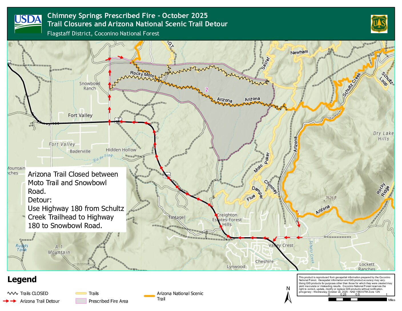
The Coconino National Forest is planning prescribed fire operations near Flagstaff, and they estimate work to begin on Tuesday, November 4 and continue throughout the week as weather conditions allow. Prescribed fires to help reduce overgrown vegetation to help protect local communities, infrastructure and natural resources from wildfires. This will impact segments of Passages 33 (Flagstaff Urban Route) and 34 (San Francisco Peaks) between Snowbowl Road and Schultz Pass Road. Click here for a map of the closures and detour along Highway 180 (For Valley Road). Prescribed fires planned for the area include: · Flagstaff Urban Interface North Weatherford (Flagstaff Ranger District: 7 miles northeast of Flagstaff) · Flagstaff Urban Interface Chimney Springs (Flagstaff Ranger District: 5 miles north of Flagstaff) Watch for warning signs along roads and trails near all prescribed fire areas before and during burns. Residents and visitors may experience smoke during the prescribed burns. For more detailed information about air quality, go to AirNow online or download the app.
Read More
Location
- Fisher Point to Passage 34 Junction
Length
- 15.4 miles
Resources
- MAP
- PROFILE
- TRACK
- Waypoints: GPS | MP
- Arizona Euro-American History
- USGS Topographic Maps: Flagstaff East, Flagstaff West and Humphreys Peak.
- Coconino National Forest – Visitors Guide.
- Coconino National Forest – Recreational Opportunity Guide.
- Coconino National Forest map.
- BLM Information Center maps.
Southern Access Point: Fisher Point
- GPS Coordinates: 35.15093° N, 111.59998° W
- NOTE: This trailhead is not directly accessible by vehicles. The nearest vehicle access point is on Babbitt Drive near the I-40 underpass at 35.188155° N, 111.631395° W.
Access
Fisher Point has no road access. The closest trail access is on Trail #106 from Canyon Vista Campground, 4 miles south of Flagstaff on FR3.
Northern Access Point: Schultz Pass
- GPS Coordinates: 35.27279° N, 111.65262° W
- NOTE: This trailhead is not directly accessible by vehicles. The nearest vehicle access point is on FR 420 (Schultz Pass Road) at 35.272490° N, 111.647840° W.
Access
To reach the starting point, drive on Interstate 17 (or I-40) to downtown Flagstaff, and drive north on Highway 180 (North Fort Valley Road). After you pass the Sechrist School on the right (east), continue 1.5 miles and then turn right (northeast) on Schultz Pass Road (FR 420). Follow this paved road 0.7 mile, turning left (north) at the fork in the road. Continue north for 3.9 miles to a small parking area on the right (south) side of Schultz Pass Road. The AZT can be found on the north side of Schultz Pass Road across from the parking area. Passage 33 crosses Schultz Pass Road at this location and connects to Passage 34 on the north side of Schultz Pass Road.
Trail Route Description
Passage 33 is an urban route across the center of the city of Flagstaff. This section begins at the bottom of Walnut Canyon near Fisher Point and uses a combination of dirt paths and asphalt to wind its way across the city and eventually to reconnect to the AZT’s Passage 32 north of Flagstaff.
The route follows several drainages, climbs over small ridges, and passes through an underpass at one of the city’s busiest intersections at Ponderosa Parkway (formerly Enterprise Road). The AZT climbs to McMillan Mesa on city streets and the Flagstaff Urban Trails System. This section provides easy access to restaurants, coffee shops, grocery stores, hotels, gear shops and more!
North of the city, the trail enters Buffalo Park and the Dry Lake Hills Trail System. It continues uphill to the national forest boundary and eventually reaches a junction that connects back to Passage 34.
Difficulty
- Moderate
Season(s)
- Spring, Summer and Fall
- Current weather forecast
Water
Water may be found year round at numerous businesses along the route in Flagstaff and at the Buffalo Park Trailhead. Check the online Arizona Trail Water Report for current information at https://aztrail.org/explore/water-sources/.
Notes/Warnings
- All the water found in creeks and springs on this passage should be purified prior to use.
For more information
- The Passage Steward
- City of Flagstaff, 211 W. Aspen Ave., Flagstaff, AZ 86001 (928) 779-7632.
- Coconino National Forest, Flagstaff Ranger District, 5075 N. Hwy 89, Flagstaff, AZ 86004 (928) 526-0866.
- BLM Information Center (602) 417-9300.
Current Passage Info

Camping Ban Near Flagstaff Impacts Passages 31, 32, 33, 34
September 5, 2023
The Coconino National Forest has expanded the boundaries of the existing year-round camping and campfire ban located adjacent to the City of Flagstaff in an attempt to lower the hazard from human-caused wildfires. This information can be located on all Arizona Trail navigational resources, including the FarOut app, topo maps, passage maps, website, and other important resources so AZT users know where they can camp outside the restricted areas. For thru-hikers utilizing the Flagstaff Urban Route (Passage 33), the longest distance to cover is 13.5 miles – from Flagstaff to Snowbowl Road. Section hikers have much greater distances to cover to avoid the camping ban area, especially along Passages 32 and 34. In addition to addressing the immediate concern for future large human-caused wildfires, the expansion is part of a long-term risk reduction strategy focused on forest health and resiliency. The change was made in response to public feedback, with support from the Arizona Trail Association. If you're planning multi-day trips on the AZT near Flagstaff, please be aware of where you can and cannot camp.
Read More
