


thetrek.co~ MAY 20TH : GOOD ZEN Part 9: Oracle to Kearney: The Prometheus of Poo Much of the land after Oracle is a flat expanse between mountains. A good place for music, audiobooks, or conversation. The trail flew by for once, and with Mt. Lemmon a recent memory, Ice Cream and I were grateful to have some cruisy ground to hike on; it leaves plenty of breath for conversation, and we used all of it to dive deep into how our upbringing had affected our psychologies and our strategies for overcoming weaknesses we had inherited from our ancestors. And, as Forrest Gump says, That’s all I have to say about that. Read more
Read More
Location
- Freeman Road Trailhead to the Gila River
Length
- 28.2 miles
Resources
- MAP
- PROFILE
- TRACK
- Waypoints: GPS | MP
- Arizona Euro-American History
- USGS Topographic Maps: Black Mountain, Crozier Peak, Kearny and Grayback.
- BLM Information Center maps.
Southern Trailhead: Freeman Road Trailhead
- GPS Coordinates: 32.87109° N, 110.88256° W
Access
From Mammoth, drive north on Hwy 77 to the town of Dudleyville. Turn left (west) on Dudleyville Road to the center of the community and locate San Pedro Road. Head west on San Pedro Road, where the road soon turns to dirt. Cross the San Pedro River * (usually dry or very shallow) and then turn north at intersection and follow road north along the river (Camino Rio) for 0.5 mile. Turn left (west) on Freeman Road. Cross railroad tracks and continue for 12 miles to the trailhead.
*San Pedro River can experience heavy flows during wet times of the year and may become impassable. Use caution and assess conditions before attempting to drive across the river. If this route is unsafe, you can approach from Freeman Road from Hwy 79 and/or Willow Springs Ranch Road from Hwy 77, which leads to Freeman Road.
Northern Access Point: Kelvin-Riverside Bridge
- GPS Coordinates: 33.10228° N, 110.97494° W
Access
From the town of Superior, take AZ 177 south for 15.2 miles (MP 152.1) and turn south onto Florence-Kelvin Highway (next to RR crossing) for 1.2 miles through the community of Kelvin and cross the Kelvin Bridge. Passage 15 approaches the bridge from below the rock outcrop along the Gila River and ends at the south end of the old bridge. Parking is limited here since the new bridge was completed in 2018. Ample parking is available at the Florence-Kelvin Trailhead ~1.5 miles further west on the Florence-Kelvin Highway. Another option is the BLM trailhead at the end of Centurion Road (one-half mile into the passage northbound). Either location provides easy access to the Arizona Trail .
From Florence, drive 1.5 miles south on AZ 79 and turn left (east) on the dirt Florence-Kelvin Highway. Continue 31 miles to the town of Kelvin and a historic bridge over the Gila River.
From the town of Hayden/Winkleman, drive northwest on AZ 177 about 16 miles then south (left) toward Kelvin. Continue 1.2 miles to the bridge.
Trail Route Description
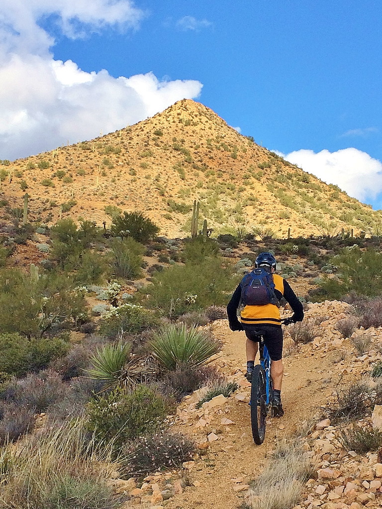
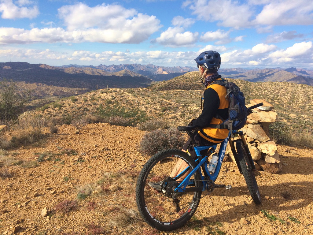
Passage 15 rolls across a remote section of the Sonoran Desert up to the foothills of the Tortilla Mountains, and then down to the Gila River. This section is hot, dry, and exposed but with a unique, rugged beauty that is synonymous with the desert.
It features moderate miles along single and doubletrack trails through rolling desert terrain. The trail crosses sandy washes and several ranch roads, and passes large boulder piles and unique rock formations. It features mesquite trees, ocotillo, and cholla cacti, while spring wildflowers, such as yellow brittlebush, desert globemallow, and the magenta petals of the strawberry hedgehog cactus, line the trail and color the hillsides.
The trail descends through Ripsey Wash and its forest of swollen saguaros, and then ascends into the foothills of the Tortilla Mountains. The toughest part of this section is the ascent up the “Big Hill,” a two-mile exposed climb with a series of switchbacks that leads to a scenic ridgeline with expansive views. The scenery remains impressive as the trail continues across the ridge and eventually descends towards the Gila River.
Difficulty
- Moderate
Season(s)
- Fall, Winter and Spring
- Current weather forecast
Water
Water sources are very limited along this passage. Plan to bring your own water. All man made waters tanks and sources can only be used with the consent of the owner.
Notes/Warnings
- All water along this passage should be purified prior to use.
- Although this passage crosses State Trust Land, a permit is not required as long as you are on or near the Arizona Trail.
- Please respect all livestock operations in this area. Close all gates along the trail.
- For a bit of local history, download the January 1931 Arizona Historical Review from http://hdl.handle.net/10150/623320 and see “The Escape of the Apache Kid” by Mertice Bruce Knox, page 77.
For more information
- The Passage Steward
- Arizona State Land Department, 1616 W. Adams St., Phoenix, AZ 85007 (602) 542-2506.
- Bureau of Land Management, Tucson Field Office, 3201 E. Universal Way, Tucson, AZ 85756 (520) 258-7200.
- BLM Information Center (602) 417-9300.
Current Passage Info

Rainwater Collector Installed Along Arid Segment of Arizona Trail in Pinal County
April 25, 2023
On April 6, Arizona Trail Association staff and volunteers completed installation of a Remote Rainwater Collector along a particularly arid segment of trail on Passage 15 in Pinal County. This unit is located north of the Freeman Road Trailhead on the ancestral lands of the O’odham and Western Apache, and holds 1,500 gallons of water. This is the second remote collector the ATA has developed in an effort to provide a reliable source of water in areas that have been particularly challenging for long-distance trail users who often rely on water filtered from earthen cattle tanks. Like all sources along the AZT, water from this unit must be purified through mechanical, chemical, ultraviolet, boiling, or other treatment methods before consumption. The 420-square-foot steel apron catches rain as it falls from the sky, and is stored within a poly tank that is protected on all sides by steel panels. Arizona’s rainy seasons are opposite the most popular thru-hiking and riding seasons, so the tank will fill with winter rains to be used in the springtime; and summer storms replenish the tank for use in the autumn months. Because the water never receives direct sunlight, algae will not grow. Water is accessible...
Read More
