


Norovirus is a highly contagious virus that causes acute gastrointestinal illness and has recently affected hikers and bikers along certain sections of the Arizona National Scenic Trail (AZT), particularly around Kearny, Superior and Roosevelt. This advisory is intended to help trail users understand the risk and take proper precautions. What is Norovirus? Norovirus spreads easily through contaminated food, water, surfaces, or person-to-person contact. Symptoms typically include: Nausea Vomiting Diarrhea Stomach cramps Symptoms often appear 12–48 hours after exposure and can be intense but typically resolve within a few days. Preventive Measures for Trail Users Wash Hands with Soap and Water -- alcohol-based hand sanitizers are not effective against norovirus. Use soap and water, especially after using the bathroom and before eating. Practice Safe Food Handling Cook food thoroughly. Avoid sharing utensils, water bottles, or food with others. Maintain sanitation in the Backcountry Dig catholes 6–8 inches deep and at least 200 feet from water sources, campsites, and trails. Pack out trash and used toilet paper if possible. Treat Drinking Water Properly -- boil water or use chemical disinfectants. Standard filters may not remove norovirus. If You Get Sick Isolate yourself from other trail users to reduce the spread. Stay hydrated...
Read More
Location
- Picketpost Trailhead to Rogers Trough Trailhead
Length
- 17.8 miles
Resources
- MAP
- PROFILE
- TRACK
- Waypoints: GPS | MP
- Arizona Euro-American History
- USGS Topographic Maps: Picketpost Mountain and Iron Mountain.
- Tonto National Forest – Superstition Wilderness Map.
- Tonto National Forest map.
- BLM Information Center maps.
- “Hikers Guide to the Superstition Wilderness” by Jack Carlson and Elizabeth Stewart, Clearcreek Publishing, Tempe, Arizona.
Southern Trailhead: Picketpost Trailhead
- GPS Coordinates: 33.27184° N, 111.17643° W
Access
From Florence Junction, drive east on US 60 for 9 miles. After mile marker 221, continue 0.5 miles and turn right (south) onto FR 231 (this point is 4 miles west of the town of Superior on US 60.) Drive 0.4 miles and turn left onto FR 310. Continue 0.6 miles, and then turn right at a sign for Picketpost Trailhead. You will see the large metal AZT sign marking the trailhead in 0.1 miles.
Northern Trailhead: Rogers Trough Trailhead
- GPS Coordinates: 33.42223° N, 111.17325° W
Access
From Florence Junction, travel east on US 60 for 1.8 miles, turn left (north) onto Queen Valley Road, continue 1.8 miles, and turn right (east) on FR 357. Drive 3 miles and turn left (north) onto FR 172 at a sign for Roger’s Trough Trailhead (there is a sign for FR 172 about 20 yards after the turn). Continue 9.2 miles to a fork and bear right onto FR 172A. Follow this road 3.7 miles, bear left at an intersection with FR 650, and continue 0.4 miles to a very large parking area. The trail departs from the north end of the parking lot.
From the rest stop in Superior, travel west about 12 miles on US 60 to Queen Valley Road and follow the directions above. Previous directions from Superior are no longer applicable since FR 357 has been closed to through traffic.
Trail Route Description
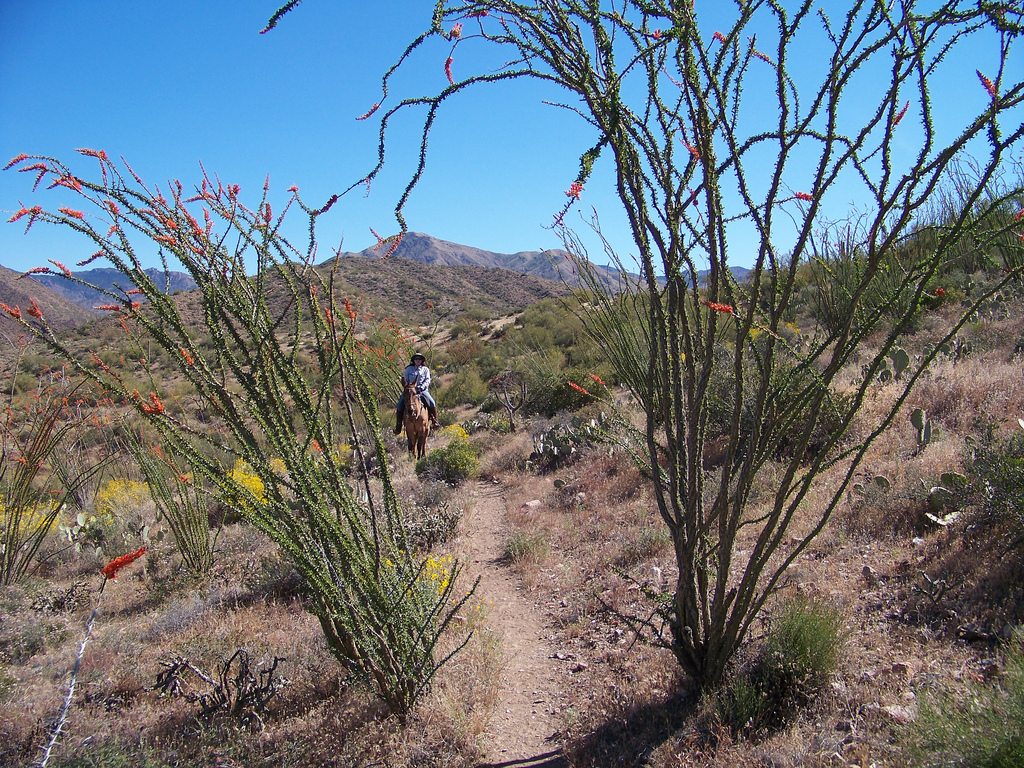
Passage 18 continues north through Tonto National Forest and enters the Superstition Wilderness. This section starts at Picketpost Trailhead and ascends from the desert canyons up to the higher elevations on the east side of the Superstition Wilderness. This section is mostly singletrack, with occasional dirt roads, and features beautiful Sonoran Desert landscapes with a variety of cacti and colorful springtime wildflowers. This area is also home to a variety of wildlife, including deer, rabbits, javelinas, quail, rattlesnakes, and the elusive Gila monster.
Throughout this passage the trail rises and falls across ridgelines and through picturesque canyons with colorful geology with panoramic views of the Superstition Mountains to the northwest, Picketpost Mountain to the south, and the Apache Leap formation to the east.
Difficulty
- Moderate
Season(s)
- Fall, Winter and Spring
- Current weather forecast
Water
Water can often be found at Mud Spring Box and seasonally in many of the drainages. Check the online Arizona Trail Water Report for current information at https://aztrail.org/explore/water-sources/.
Notes/Warnings
- All water along this passage should be purified prior to use.
- The Tonto National Forest is closing the gate at Picketpost TH between dusk and dawn now. There’s a site host there overnight so folks won’t get locked in, but no late night arrivals.
- Whitford Canyon is a notorious flood path so be aware of the weather and don’t enter this area when rain is imminent.
- Elisha Reavis used part of this route in the 1890’s to haul fruits and vegetables from his ranch to Superior.
For more information
- The Passage Steward
- Tonto National Forest, Globe Ranger District, Rt. 1, Box 33, Globe, AZ 88501 (928) 402-6200.
- BLM Information Center (602) 417-9300.
