


Grand Canyon National Park has confirmed that hikers are allowed to walk on the paved road to avoid the snowy AZT during the spring season before the road opens, typically on May 15. Mountain bikers are not allowed to ride the road and must follow the trail. The Park reiterated that hikers walking the plowed and paved North Rim Road should be aware of vehicles and snowplows; this means no camping, campfires, or full spread meals in the middle of the road. Bicyclists are technically grouped in with motor vehicles so they are not allowed to use the paved/plowed road and should stick to the AZT during early-season conditions. Is this logical, practical, or safe for mountain bikers? Absolutely not. And is this supported by the ATA? Nope! But it's a Grand Canyon National Park policy, developed in coordination with Arizona Department of Transportation.
Read More
Location
- Kaibab National Forest boundary to Telephone Hill Trailhead
Length
- 20.7 miles
Resources
- MAP
- PROFILE
- TRACK
- Waypoints: GPS | MP
- Arizona Euro-American History
- USGS Topographic Maps: Little Park Lake, Dog Point and Telephone Hill.
- Kaibab National Forest map.
- BLM Information Center maps.
Southern Access Point: Kaibab National Forest boundary
- GPS Coordinates: 36.33775° N, 112.10248° W
Access
From Jacob Lake, drive south on AZ 67 for 26 miles and turn left (east) onto FR 611 (4.5 miles north of the Grand Canyon National Park entrance station and 1 mile south of Kaibab Lodge). Drive 1.1 miles and turn right (east) onto FR 610. Wind south and then east 5.1 miles to a pullout on the north side of the road, near a brown AZT post.
Northern Access Point: Telephone Hill Trailhead
- GPS Coordinates: 36.55147° N, 112.17560° W
Access
About 13.5 miles south of Jacob Lake on AZ 67, look for a sign pointing to FR 429 on the west side. Do not turn right onto FR 429, but instead turn left (east) onto FR 241. In 0.1 miles, the AZT crosses the road, but there is no parking here. Continue another 0.1 miles to a little campsite on the left, where you may be able to park.
Trail Route Description

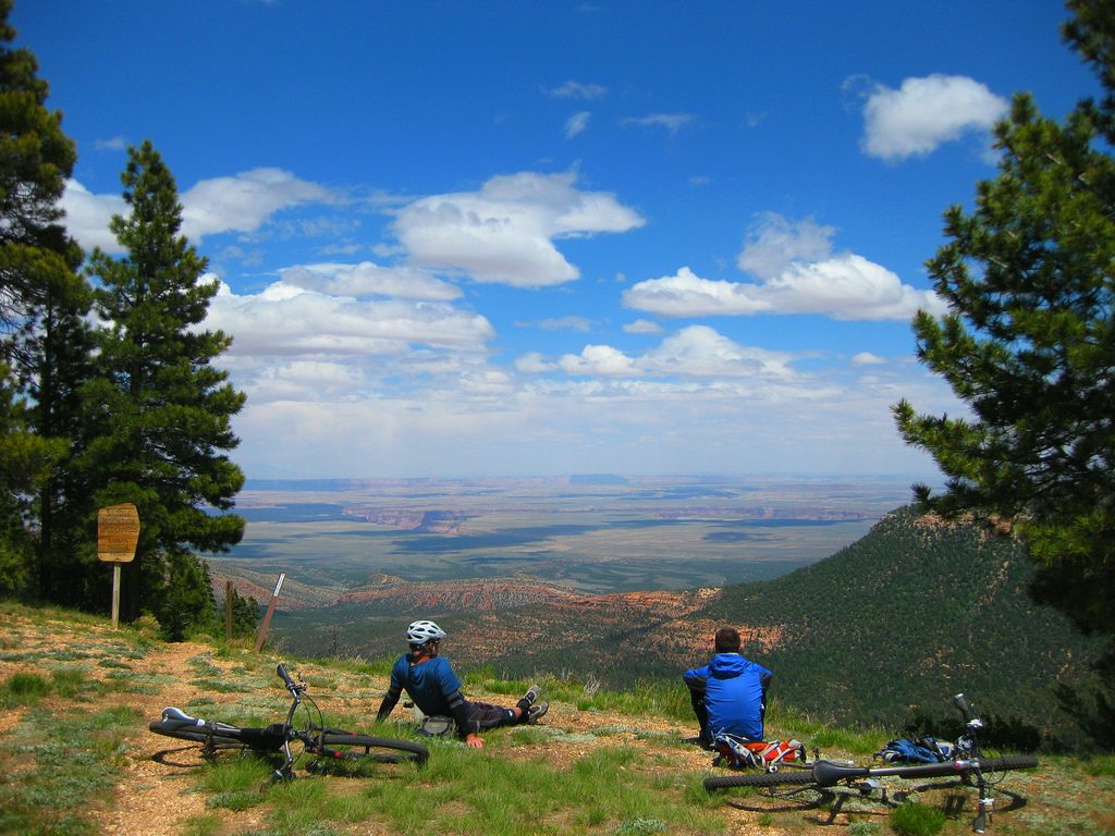
Passage 40 begins at the Kaibab National Forest boundary and traverses through an idyllic forest of spruce, pine and aspen. Located in a much-overlooked area of northern Arizona, this section offers easy and pleasant travel along singletrack through gently rolling terrain.
As the trail winds along the East Rim of the Grand Canyon, it dips into tranquil meadows and passes by the East Rim Viewpoint. It features scenic views and the peaceful valley of Tater Canyon.
The East Rim Viewpoint is a highlight of this section with breathtaking views of Saddle Mountain Wilderness, Marble Canyon, Vermillion Cliffs, and Navajo Mountain in the distance.
Difficulty
- Easy to Moderate
Season(s)
- Spring, Summer and Fall
- Current weather forecast
Water
There are seasonal an probable water sources on this part of the Kaibab Plateau. Check the online Arizona Trail Water Report for current information at https://aztrail.org/explore/water-sources/.
Notes/Warnings
- All water along this passage should be purified prior to use.
- The Arizona Trail is marked with brown fiberglass posts with a Kaibab Plateau Trail decal near the top.
- When the AZT is buried under snow in the springtime, hikers are allowed to walk on Hwy 67 before the road opens, typically on May 15. Mountain bikers are not allowed to ride the road and must follow the trail. Hikers walking the plowed and paved road should be aware of vehicles and snowplows; this means no camping, campfires, or full spread meals in the middle of the road.
For more information
- The Passage Steward
- Kaibab National Forest, North Kaibab Ranger District, P.O. Box 248, Fredonia, AZ 86022 (928) 643-7298.
- Kaibab Plateau Visitor Center, Jacob Lake, AZ (928) 643-7298.
- BLM Information Center (602) 417-9300.
Current Passage Info

Handmade AZT Mugs
May 28, 2019
We are delighted to offer the third in a series of commemorative mugs celebrating the natural beauty of the Arizona National Scenic Trail! This handmade mug features a scene from the Kaibab Plateau Passage of the AZT near the North Rim of Grand Canyon, including lush meadows, dense fir forests, and an American bison. This was the first segment of Arizona Trail officially designated, and remains one of the highlights along the 800-mile trail (it feels more like Canada than Arizona). These mugs are a membership benefit to anyone joining or renewing your membership at the Ironwood level ($100/year) and above. Support the ATA and enjoy your favorite beverage while dreaming of adventures in northern Arizona this summer.
Read More
